Quantcast
Channel: Mike Wilhelm's Alabama Weather Blog Bamawx.com

Memories of April 27, 2011 – Mississippi & Alabama Storm Chase Account

$
0
0

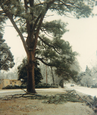
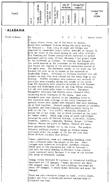
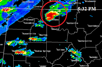
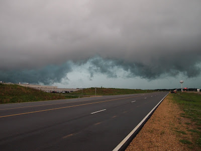
5:10 p.m. 4/27/11, Tuscaloosa, Alabama

Memories of April 27, 2011 – My Storm Chase Account

This is a personal account of my experiences as a storm chaser on April 26 and 27, 2011 in Mississippi and Alabama. This is just my story, as best as I can tell it. Over time, as information becomes available and my memories are triggered, I will periodically update this post with additional narrative, links, photos, or video.

I partially regret that I have waited eight months to compose a synopsis of my activities during the historic April 27, 2011 Super Outbreak of Tornadoes. The main reason we chase is to provide a public service by assisting in the warning process. My partner, John Brown and I have been Skywatchers for ABC 33/40 in Birmingham for many years. James Spann, Jason Simpson, Brian Peters, and Ashley Brand have assembled a great system of communicating with and training storm spotters for Central Alabama. It has been an honor to serve with this group for several years. John, Rick Lipscomb and I have spoken about our chase among ourselves and with friends, and we have all appeared on various local and national media outlets. Twenty four hours after the Tuscaloosa tornado, I spoke live by phone with KTEN TV in Texas. My most extensive interview was live on WHNT Channel 19a few mornings later with Meteorologist Ben Smith. This is a shorter version of the interview as seen on the evening news. John was interviewed by ABC News Nightline and other media outlets. We told our story on the Weatherbrains podcast. In these interviews we told the story, but eight months later, I feel ready to relive the day in detail and put my memories in writing. I know John and Rick agree that it was a day that we will never forget and it will haunt us the rest of our lives. I have also spoken about the day on a few occasions with close friends, especially some of my closer friends in the weather community. Frankly, like others who witnessed the tragedy unfold, I have found it easier to spend the last eight months avoiding the subject. I usually post about my chase accounts immediately on this blog, but to this day I have said very little about my experiences on April 27. Witnessing the Tuscaloosa tornado was a shocking experience. I remember the next day my friend and fellow chaser, Jennifer New, asked how I was doing emotionally. I thought I was doing pretty well, but the depth and the shock of the tragedy really started hitting home in the coming days. She has encouraged me to tell the story. I think it is a story worth telling, and if I wait too long I will begin to forget details.

The story of my April 27, 2011 storm chase actually began eight days earlier. I pay close attention to forecast models, especially during the primary severe weather season. I also pay close attention to forecasters who look at the models closely who are much more knowledgeable than I. As early as Tuesday April 19, ABC 33/40 Chief Meteorologist James Spann mentioned in his morning “Weather Xtreme” video (this is his map discussion that he usually produces twice a day) that severe weather was a possibility on the 27th. By the next morning, the 20th, James said it could be a “significant severe weather outbreak”. On Friday April 22, James was mentioning the possibility of tornadoes, as was the National Weather Service Birmingham in their Hazardous Weather Outlook. Models were quite consistent in portraying a setup favorable for tornadoes as many as five days in advance. I asked to be off work on Friday the 22nd. As April 27 approached, confidence continued to increase that there would be multiple waves of severe weather, including the possibility of long-tracked supercells. By Monday the NWS Birmingham was referring to the storm system as “dangerous” and predicted the possibility of “strong, long-track tornadoes”. I later wrote an extensive blog post showing details of how local media and NWS offices forecasted this event.

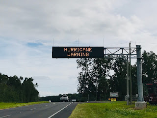
With all of these ominous forecasts and the staggering severe weather indices that models were showing, Wednesday the 27th was obviously a day that I wanted to be out chasing. I was getting nervous, though, because I still had not been approved for leave at work. I finally received approval at 3:30 Tuesday April 26. I immediately texted my partner John Brown and we started formulating plans. He and I exchanged several texts and calls that evening. I also was contacted by my friend Rick Lipscomb, an Alabama native, who was going to drive up from South Georgia and tandem chase with John and I. The idea of the system coming in the form of two or three waves was still being shown by the models late Tuesday afternoon. By 4 p.m. portions of North Mississippi were placed in a "High Risk" area by the Storm Prediction Center. After leaving work, I immediately filled my vehicle with gasoline, drove home, studied every model and forecast I could look at, and called John and Rick.

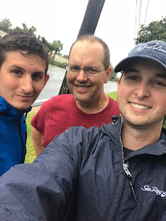
The three of us decided to begin the chase that night. We decided to meet in Cullman around 11 p.m. at the Days Inn parking lot on the US 278 exit on Interstate 65. I drove from Huntsville and got there at 11:10 and caught about an hour of sleep in my vehicle while I waited for John to arive from Birmingham and Rick to arrive from Georgia. After Rick and John arrived just after Midnight we discussed our plan further. We didn’t necessarily expect to see a whole lot at night but we wanted to be positioned in the best possible location for the main events on the 27th. We decided to head west on US Highway 278. Around 1:15 a.m. the Storm Prediction Center issued a "High Risk" for North Alabama and surrounding areas. We saw our first storm in Hamilton, Alabama around 3:30 a.m. It was a strong thunderstorm with intense lightning and gusty winds. Jennifer Watson of WVTA Tupelo reported a severe thunderstorm warning for Lamar and Marion counties in Alabama until 4:30 a.m. with the possibility of winds of 70 mph. As we headed toward Tupelo on US 78, we encountered another storm between Hamilton and the Alabama State line. The lightning was almost constant between 3:45 and 4 a.m. These were the first of countless storms we would witness over the next 36 hours.

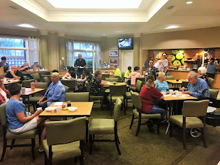
When we got to Tupelo we pulled into a Waffle House parking lot. I studied ongoing weather data as well as forecasts, and tried (mostly unsucessfully) to take a brief nap. Storms continued to fire that morning. Not long after breakfast, Pontotoc County, northwest of Tupelo, was placed under a tornado warning. At 9:15 a.m. there was a brief tornado at Esperanza, Mississippi, with minor damage. The clouds were impressive and very picturesque.


9:29 a.m., northwest of Tupelo, Mississippi

We saw what might have been a wall cloud, but nothing definite. As with all of the storms we had seen, the winds were very gusty and the lightning was intense. I recorded some video of the skies when we ate at Waffle House, along with the storm west of Tupelo on US 78 from 9:12 and 9:30. The video includes my discussion with Greg Nordstrom, Instructor of Meteorology at Mississippi State who is also a phenomenal storm chaser. He expressed grave concern about the nature of the environment, the type of supercells that we might see during the afternoon, and the danger it would pose to the public and also to any inexperienced chasers who might be out driving.

While we were in North Mississippi during the morning we were hearing about severe storms with numerous damage reports in Alabama counties such as Marion, Pickens, Fayette, Tuscaloosa, Walker, Jefferson, and Shelby. We later learned that the damage was more extensive than initially reported and that some of the damage was produced by tornadoes. After the storm we witnessed northwest of Tupelo, the temperature dropped into the 50’s in northeast Mississippi. We made the decision to drive southeast into West Alabama where the air was more unstable.

As we drove south through Marion, Fayette and northern Tuscaloosa counties that morning we began to realize that the morning round of storms produced a great deal of damage to the communications infrastructure. This would prove to be a significant problem later in the day as it hindered people from receiving warnings. Power, cell phone, and internet service was out due to the extensive damage produced by the morning severe weather events. John, Rick, and I were handicapped for several hours without access to much in the way of weather data. We pulled up to a gas station and couldn't purchase gasoline because they were out of power and the credit card machines were down. Our instincts told us that supercell storms that afternoon would move through the I 20-59 corridor, but now we had added reason to chase in that area. We did not want to be stuck in Fayette, Marion, or Walker counties without data or cell phone service. For quite some time, John and I were chasing "old school", relying on nothing but NOAA Weather Radio, scanner, and occasional reports on commercial radio. Driving south through northern Tuscaloosa County we saw numerous trees down from the morning storms on Highway 171. I received a call from my friend Craig Woodham. He and his wife were considering driving home to Tuscaloosa from Mobile that afternoon. I advised against it. Craig told me that a family we know, Reginald and Danielle Eppes, who live in Coaling in eastern Tuscaloosa County, had apparently been in a tornado that morning at their home. You can listen to their miraculous story on National Public Radio, here. Here is another story on them in the UK's Daily Mail. Craig didn't know all of the details at the time, but that was a sad precursor of things to come for the Tuscaloosa area.

Jim Stefkovich, Meteorologist-in-Charge of the NWS Birmingham gave a chilling and accurate prediction of what to expect after the morning storms passed, live on 100 WAPI's Matt Murphy Show late in the morning of April 27.

John, Rick, and I stopped at the Burger King in Northport, across the Black Warrior River from Tuscaloosa just after Noon. The temperature was 20-25 degrees warmer than what we experienced near Tupelo. It was now up to the lower 80’s here! The air was very humid and turbulent. As we ate at Burger King, John Brown uttered these words, “Someone is going to die today. They just don’t know it yet.” Those words hit hard but rang true to Rick and I. One thing I like about John and Rick is they take the public service aspect of chasing very seriously. It is our goal that we can play a part in the warning process so that loss of life can be prevented. John’s words were sobering, and sadly, all too true.

We stayed in Northport for nearly two hours, watching the satellite, radar, and mesoscale analysis page on the SPC site very closely. The severe weather parameters were off the chart! We felt like we were in the prime location, but all of North and Central Alabama was in danger. Finally, just before 2:00 p.m., we decided to head west towards Pickens County, near the Alabama/Mississippi border, west of Tuscaloosa. Storms were exploding in Mississippi.

By 3:30 we were on a tornado-warned storm in Pickens County. This was the scariest part of the chase. John, Rick, and I debated as to what we needed to do to be safe. We were not really in the safest place relative to the storm. We were on the north side of Pickensville as the tornado formed to our east. After it formed and we drove east to follow it, we ran into tree and power lines in the road. This storm eventually produced EF4 damage in Cordova in Walker County. This is my video of the formation of this tornado, along with the location it touched down.

When we came up on the initial damage (trees down on the road), our chase came to a major crossroads. Should we try to follow this storm or try to intercept a storm entering Greene County that was on a course for Tuscaloosa? John suggested hightailing it to Tuscaloosa. I was not confident that we could make it to Tuscaloosa ahead of the storm. But seeing that we had little alternative and considering that we always had the option of pulling back to be safe, I agreed with John. It was about 3:35 p.m. when we made the decision to go to Tuscaloosa. It was around this time that we were seeing ABC 33/40 cover a tornado live on towercam in Cullman. I tried calling my family there to make sure they were safe.

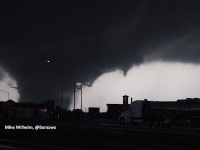
John was driving his truck. Rick was following us in his truck. We made our way to US Highway 82. This thoroughfare brings you into Tuscaloosa County from the west. We passed through the communities of Buhl and Coker, west of Northport. I was still unsure if we were far enough ahead of the storm to have time to get south in front of it. To make matters worse, Rick was behind us, and we didn't know how far. I told John we needed to hustle south over the Black Warrior River and get down I-359 as soon as we could. As we crossed the river, I looked west out of the passenger window. I saw an amazing display of cloud to ground lightning due west of Tuscaloosa. Bolts of lightning were striking in what appeared to be the same location repeatedly. Comparing what I was seeing to our Gibson Ridge Radar software, the lightning was striking out of the rain free base immediately ahead of what was later confirmed to be the tornado. It was a hectic time. We were having to navigate and keep track of the storm on radar and in the sky. John's GPS link to the radar software was a great tool in helping us get in a safe place relative to the storm. But it was not the only thing. Years of spotter training and a knowledge of the geography of the area served us well. We could not see the tornado at this point. We knew by now we were safely ahead of the storm but we were concerned about Rick. If he followed the same route, we wondered if he would run into the tornado. Frustratingly, I could not reach him by phone.

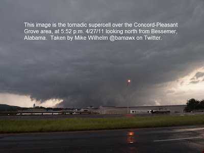
At this point, emotions and adrenaline were off the charts. I had a sense that this was going to be a major tornado by the time it approached Tuscaloosa. We then heard a report on ABC 33/40 that Meteorologist John Oldshue had streamed live video of a tornado leaving Greene County and entering Tuscaloosa County. Around this same time, Dr. Tim Coleman and Brian Peters were witnessing and reporting a large tornado on Interstate 22 in Walker County. I suggested to John that we go east on I 59-20 and pull off the interstate at the McFarland Boulevard Exit (U.S. Highway 82). We were on the ramp so in addition to having a great view of the sky we also had a very important escape route to the south or the east if we needed it.

After we pulled off, we grabbed our cameras and video cameras. While filming, I continued to try to reach Rick. I finally reached him by phone. He was seeing the tornado and seemed to be safe before I lost the connection again. Here is his video. As I said in my video, we really were in the perfect spot. We saw the tornado gradually appear on the horizon. As it did, within seconds, it appeared massive as it approached Tuscaloosa. John managed to report this on the ABC 33/40 Skywatcher chat. This tornadic storm in Tuscaloosa was streamed live on Ustream from 4:40 until 5:20. ABC 33/40's James Spann and Jason Simson covered the storm live as did The Weather Channel's Greg Forbes.

Words cannot express what went through my mind as I witnessed this beast approach a town I love and lived in for eight years. As it approached I imagined someone was about to be killed while he walked to his car after paying for his gas. I imagined a little old lady who might lose her life as she walked out of the grocery store. My mind was racing with thoughts of people being unaware of the danger headed their way. I felt helpless! It was too late to even send another report to help Tuscaloosa residents. All I could do was pray!

My video:


John's video:


If you watch my video, you will hear me say repeatedly, "Jesus help these people," or "Jesus help these people be safe." I have been amazed at the amount negative response to this on YouTube. There were so many hateful, derogatory, obscene, mean, and attacking comments about the fact that I prayed. I had many people ask that I turn the comments off on the video because some were so vile. I thought about it but I think it reflects the reality of this world and we should let people voice their opinions. Also, about the video, I took it down from YouTube for several days. It seems it was being stolen by certain media outlets and I was advised to bring it down until it could be protected. Thanks to Kendra Reed with KDR Media for help with this. It was a shame because John helped me get it online at his house within two hours of the tornado and it garnered a lot of interest. Not that it matters in the big scheme of things, but it would have had hundreds of thousands of more views.

John and I followed the tornado up 20/59 from Tuscaloosa to Birmingham. Some have asked why we didn't try to drive into Tuscaloosa to help assist victims. It isn't that we were unwilling to do something to help, but there was no way we could have been in a position to get to where help was needed. Back in 1995 I helped rescuse a tornado victim, but it was a rare situation where I just happened to have easy access. Once the authorities arrived I was no longer needed. We stopped near Bessemer where John shot some video and I took some still photographs. John and I noticed that the storm became more rain-wrapped as it approached Jefferson County. We saw the storm as it was tearing up places like Concord to our north.


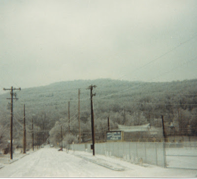
The next day John and I witnessed the destruction at Concord. John was being interviewed by ABC News Nightline. One of my best friends, Tom Windsor, lived in Concord for years. They were also affected by the April 8, 1998 F5 tornado. The destruction we witnessed the next day was unbelievable.


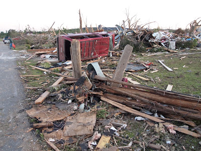
4/28/11 7:28 p.m. Concord, Alabama

After seeing the damage in Concord on April 28, I thought there was a lot of high end EF4 damage. There were a lot of bare slab foundations. It was very sad to witness. Four or five people (at least) died in that little neighborhood. If that was the only community affected in the state it would have been on the national news. Sadly, it was only a small fraction of the horror our state experienced. I hope I never see anything like this again. There was warning. But there was nothing these people could do to be safe from an EF4 tornado unless they had access to an underground shelter. Our minds will never grasp the magnitude of this tragedy. When I witnessed first hand the kindnesses given to those affected in the wake of the storms, I am prouder than ever to be an Alabamian.

Back to the chase. As we approached Birmingham, John asked me if I minded ending the chase. He was concerned about his family and wanted to check on them. Of course I told him that was a "no-brainer". As we approached his home in the Trussville area, we were very close to the area of circulation. We didn't know it at the time, but the tornado temporarily "lifted" just east of Fultondale. John and I tried to take shelter in a gas station but the employees had locked the door and would not let us in. We drove to John's house. His family was ok. I was finally able to get in touch and find out that my sons in Cullman were ok. By this point in the day cell phone service was becoming spotty in many areas. We uploaded my video and sent reports to ABC 33/40.

My vehicle was still in Cullman. John had to drive me back to Cullman. It was after dark and we began to wonder if the Cullman tornado hit the area where my vehicle was parked. The magnitude of the storm event was such that we had no idea, even by this hour, how many parts of the state were devastated. Everything was completely dark north of Birmingham. The North Alabama tornadoes had destroyed the power infrastructure. After we found my vehicle, surrounded by utility trucks, I drove home to Huntsville. With no power and no moonlight it was surreal driving home. The normal glow in the sky over Decatur, Madison, and Huntsville was missing. As I drove through Huntsville I only saw lights at the hospital and police station, which were running on generator power. As I pulled in my driveway, my garage door opener didn't work (of course), and as I opened the car door I heard the roar of generators in the neighborhood. I used the light of my Droid phone to get me to the back door of the house. Then I looked for candles and flashlights and a radio. I could tell from the radio that things were worse up in North Alabama than I realized.

Thus ended a very long and emotional day......

---

Here are some of other links of interest. I will be adding to this list over time.

The May 3, 2011 Weatherbrains, Episode 275, was a two hour special. Regulars James Spann, Bill Murray, Dr. Tim Coleman, and Kevin Selle were joined by John Oldshue, John Brown, and Mike Wilhelm to simply share their thoughts on the horrible April 27, 2011 tornado outbreak that has killed over 300 people across the Deep South and injured thousands more.

Dr. Jon Nese of Penn State University describes the forecasting of the tornado outbreak as well as the warning process in his weekly program, Wxyz (Weather Whys) which airs on Pennsylvania Public TV. In September 2011 I had the pleasure of visiting Dr. Nese as he gave me, Bill Murray, Ben Smith and other guests from Alabama a tour of the PSU Meteorology Department. Penn State people did a lot to reach out and help Alabamians.

WHNT 19's Michelle Stark tells the story of this historic tragedy through YouTube videos.

WSFA Montgomery's Rich Thomas showed radar history of the Tuscaloosa-Jefferson tornado.

John Brown raised money for victims selling We Are Alabama tee shirts.

ESPN visited Tuscaloosa and did a special story on the tornado recovery in May. My video was used in that story.

James Spann wrote a famous blog post about the warning process that was even covered by the media in the UK.

NOAA movie showing the rapid scan infrared imagery from the GOES-East weather satellite from April 26-28, 2011.

Miraculous story of survival and recovery of one Alabama student.

NWS Meteorologists "detective work" in performing numerous, massive storm surveys.

Crazy video someone took inside the Fultondale tornado.

Birmingham NWS Meteorologist in Charge Jim Stefkovich describes the event.

...

Coldest Day in Alabama History - 2/13/1899

$
0
0

This is from the Montgomery Advertiser, 2/14/1899. The temperature dropped to -14 on this date in Anniston in 1899.


12 below zero in Uniontown, AL in Perry County and -7 in Opelika in Lee County on this date in 1899.


On this date in 1899 the temperature dropped to five below zero in Selma, Alabama (Selma).


Mobile, AL celebrated Mardi Gras in 1899
with heavy sleet and dropped to -1.

The official low at the Fountain Heights weather office in Birmingham was -10.

Other lows included:

Tuscaloosa -7

Elba -7

Greensboro -5

Florence -11

Decatur -12

Oneonta -15

Hamilton –16

Scottsboro –16

Valley Head -18

Source: Bill Murray @wxhistorian on www.alabamawx.com

...

Joppa - Arab Tornado 2/16/95

$
0
0

Birmingham Nexrad 2/16/95 at 5 a.m. when a Tornado Warning was issued for Marshall County.

At 4:59 a.m. on February 16, 1995, an F3 tornado touched down three miles west of Joppa in extreme northeast Cullman County. It traveled through the town of Joppa, crossed Alabama Highway 69 and moved into Marshall County, just southwest of Arab, at 5:06 a.m. The tornado moved across the southern side of Arab at 5:08 and crossed over U.S. Highway 231. It finally dissipated near Browns Creek on the western side of Lake Guntersville after being on the ground for 14 miles. Six people were killed and 130 were injured. One death occurred in a house and the other five occurred in mobile homes. Five of the deaths were in Marshall County and one was in Cullman County.

A total of 157 homes were destroyed (77 in Cullman and 80 in Marshall) and 12 businesses (6 in Cullman and 6 in Marshall) were destroyed. More than 40 commercial poultry houses were demolished and at least two small trailer parks were destroyed by the tornado. The roof was ripped off Amberwoods Garden Apartments and the tornado also tore through the Joppa Elementary School.

The New York Times reported that the tornado struck with "virtually no warning". That was rather misleading. Around 4:25, lightning knocked out operations at the Huntsville NWS, including radar. Thus the Birmingham NWS was pressed into action for the Huntsville office's County Warning Area. At 4:55, the NWS Birmingham issued a Severe Thunderstorm Warning for Cullman County, four minutes before the tornado touched down west of Joppa. Noticing signs of rotation, they then issued a Tornado Warning for Marshall county at 5:01 a.m. Unfortunately, the Huntsville NOAA Weather Radio transmitter was also knocked out, so the warning message was never sent out over NOAA Weather Radio. Combine that with the fact that the tornado occurred in the early morning hours, around 5 am, with many people still asleep, and it is easy to see how people missed the warning.

Today I contacted Brian Peters, who was the Warning Coordination Meteorologist for the National Weather Service in Birmingham at the time. Here are some of his memories of the event:

"I recall there were two thunderstorms moving along parallel to one another right along the boundary between the Huntsville warning area and the Birmingham warning area. As I recall the Huntsville office went down due to a lightning strike which took down their radar but they were able to notify us. The storm that produced the Arab-Joppa tornado was just about to move into Marshall County from Cullman County, so when we issued the (tornado) warning we went with just Marshall County....this was one of those unfortunate events with everything happening at almost the same time."


Story from WHNT regarding what happened when lightning knocked the NWS Huntsville:


Huntsville television station WAFF revisited the tornado in an article in 2005:

"We started to the basement, but we didn't make it to the basement, it pretty much destroyed our house," Charlie McClendon, the tornado survivor, said. McClendon's house and 150 homes were destroyed throughout Arab and Joppa. The tornado leveled buildings and lives. One hundred and thirty people were injured, six killed. "I saw him, I got him out of the rubbage," said McClendon, Marshall County District One Commissioner. He was talking about his son in law, David Price. David died when they're mobile home was tossed in the wind. David's wife was pregnant with their first child, Will. He's now nine, and never knew his father."


Dan Satterfield's live coverage of the event for WHNT 19:


According to the Associated Press, the dead included a six year-old girl. A firefighter said that his rescue team found a one year-old baby, unhurt, under two trailers. One couple's A-frame home was lifted from its foundation, carried 40 feet, and dropped on a trailer. The couple clung to their bed and escaped serious harm.

Despite public outcry about the warning process that resulted in part from the Joppa-Arab tornado, the NWS Huntsville office was closed December 2, 1997. However, after a tremendous amount of pressure from people in North Alabama and U.S. Representative Bud Cramer, Huntsville would again have its own NWS Office. This tornado event was often cited as a reason the Tennessee Valley needed to have its own National Weather Service Office again.


Brindlee Mountain Amateur Radio Association (BMARA) at the National Guard Armory in Arab

In the aftermath of the Joppa Tornado of 1995, the Cullman County Emergency Management Agency began installing warning sirens in Cullman County as funds became available from local governments and through state and federal grants. The first siren at Joppa went on-line in February 1998.

Two other tornadoes occurred in Alabama that day. At 3:32 a.m. an F1 tornado touched down 6 miles east of Hamilton in Marion County, damaging five homes and destroying six chicken houses. It was on the ground for six miles. At 5:28 a.m., the same storm that produced the Joppa-Arab tornado produced an F2 tornado that traveled 12 miles from Marshall County into Dekalb County. Three people were injured. Ten homes were destroyed, 40 homes were damaged, and 30 chicken houses were damaged in this tornado.

Jim Cantore's coverage on TWC:


James Spann, Bob Baron, and Jay Prater's coverage:


Video of coverage by The Weather Channel:


Video of coverage by CNN:


Sources:
Meteorologist Brian Peters, NWS Retired
NWS Huntsville
NWS Birmingham
Bill Murray at Alabamawx.com
Iowa Environmental Mesonet Archives

WAFF
SFGate.com
Brindlee Mountain Amateur Radio Association
Cullman County EMA

...

20th Anniversary of Blizzard of 1993

$
0
0


Updated to include videos of coverage by James Spann, Kevin Collins, and Dan Satterfield on WBRC 6 in Birmingham. Scroll down to the bottom of the post.

None of us who are old enough to remember the blizzard of March 12-15, 1993 will soon forget it. This storm shattered snow records and caused amazing weather events from Canada to Central America.

I will focus mainly on the extreme weather Alabamians witnessed. According to the NWS Birmingham, all time Birmingham snow records include:
MAXIMUM in 24 hours 13.0 inches March 1993
MAXIMUM in a single storm 13.0 inches March 1993
MAXIMUM in a single month 13.0 inches March 1993
MAXIMUM in a single season 13.0 inches 1992-93

Below is a clip of the home video I made of the snow that fell in Huntsville, Alabama March 12 & 13, 1993. Huntsville "only" received seven inches from the storm. However snowfall amounts of greater than one foot were common, especially from Birmingham to the east and northeast. The town of Walnut Grove, Alabama, actually received 20" of snow!


All of Alabama was covered in snow. Mobile received 3". The highest total reported in Alabama was at Walnut Grove near the Blount-Etowah county line. Red Mountain in Birmingham recorded hurricane force winds according to meteorologist James Spann. Thundersnow was reported all across the state, from Huntsville to Mobile.
Here is a list of Alabama snow totals posted originally by J.B. Elliott:

20 inches at Walnut Grove
17 inches in Valley Head
16 inches in Oneonta and Bessemer
13 inches at Anniston, Talladega, Pinson and Birmingham Airport
12 inches at Thomasville, Childersburg and Scottsboro
11 inches at Sylacauga
10 inches at Cullman, Clanton and Heflin
9 inches at Thorsby
8 inches at Ashland, Centreville, Moulton and Guntersville
7 inches at Alexander City, Huntsville and Whatley
6 inches at Camden, Evergreen, Jasper, Livingston, Andalusia, Haleyville and Highland Home
5 inches at Auburn, Winfield, Muscle Shoals and Chatham
4 inches at Montgomery, Union Springs, Vernon, Tuscaloosa, Demopolis, Frisco City, Greenville, Troy
3 inches at Brewton, Hamilton, Bay Minette and Mobile Airport
2 inches at Atmore and Robertsdale
Trace at Coden and Fairhope


Here are some great links:  A Storm to Always Remember J.B. Elliott 2008

Pictures from the 1993 Blizzard James Spann 2008


Anyone Remember the Blizzard of 1993 James Spann 2008

15th Anniversary of the "Blizzard of '93" Thread on Talkweather.com 


Meteorologist James Spann's account of the storm.

James Spann posted some really cool viewer photos and stories from the storm.

Remembering the "Blizzard of 1993" NWS Birmingham

The Blizzard of 1993 WBHM FM 90.3 Birmingham

Photos WBHM FM 90.3 Birmingham

Listen to the feature story commemorating the Blizzard of 1993 WBHM FM 90.3 Birmingham

Steve Chiotakis remembers forecast and broadcast challenges WBHM FM 90.3 Birmingham

Superstorm 1993 - A Case Study

Wikipedia Storm of the Century (1993)

The Historic American Engineering Record was surveying Birmingham historic sites when the storm occurred. They took the following pictures in downtown Birmingham and in Southside. Photo 1Photo 2Photo 3

---


The video below is part one of the historic "Storm of the Century" or "Blizzard of 1993" in Alabama. These clips are in chronological order.

This clip begins on Friday morning March 12, 1993 with meteorologist Dan Satterfield as the precipitation was entering Alabama.

This clip ends just after 10 p.m. when Kevin Collins says that several inches have accumulated on secondary roads.

It includes updates that were provided throughout the evening by meteorologist James Spann, Kevin Collins, and news updates at the end of the clip by Brenda Ladun.


Below is part two of the historic "Storm of the Century" or "Blizzard of 1993" in Alabama.

During this clip, which was recorded between 10:15 p.m. and midnight, wind gusts were 37 and increased to 41 just before midnight as the storm officially became a blizzard. Thundersnow was reported for the first time around 11 p.m. Thundersnow was also reported in Huntsville and Mobile at the same time. Kevin Collins reported 4-6" of snow just before midnight.

Meteorologist James Spann and Kevin Collins of WBRC 6 report on this historic storm along with news anchors Scott Richards and Brenda Ladun.


The next video, below, is part three of the historic "Storm of the Century" or "Blizzard of 1993" in Alabama.

These clips are in chronological order. This one begins at 12 a.m. on March 13, 1993 and ends just before 1 a.m. Notice how the power is flickering at the station during the past few minutes of the clip.

The blizzard was really cranking up in Birmingham by this time. Spann reported 6-8" on the ground and winds gusted to 51 mph on Red Mountain at approximately 12:50.

Meteorologist James Spann and Kevin Collins of WBRC 6 report on this historic storm.


This is part four of the historic coverage of the "Storm of the Century" or "Blizzard of 1993" in Alabama.

These clips are in chronological order. This one begins at approximately 1:50 a.m. on March 13, 1993 and ends at 3:15 a.m. By this time snow accumulations across Central Alabama were over 8" and wind gusts atop Red Mountain at Channel 6 were recorded at 58 miles per hour. Many, if not most of the people tuned in at the time were listening on portable radios as the power was out in many areas.

Snow was accumulating as far south as the beach at Gulf Shores in Baldwin County, Alabama.

The most fascinating part of this video was during the final five minutes as photographer Jeff Thorn describes the video he made, which includes thunder and lightning.

Meteorologist James Spann and Kevin Collins of WBRC 6 report on this historic storm.


This is the fifth and final part of James Spann's and Kevin Collins' historic live coverage of the "Storm of the Century" or "Blizzard of 1993" in Alabama.

This clip begins at approximately 3:15 a.m. on March 13, 1993 and ends at 8:44 a.m. By this time snow accumulations across Central Alabama were over one foot and wind gusts atop Red Mountain at Channel 6 were continued to exceed 40 miles per hour. Many, if not most of the people tuned in at the time were listening on portable radios as the power was out in many areas.

In addition to James and Kevin, WBRC 6 anchors Scott Richards, Janet Hall, photographer Jeff Thorn, and reporter Art Franklin contributed to this coverage.

2/23/1975 Tuscaloosa F4 Tornado (Scottish Inn Tornado)

$
0
0
Forty nine people were injured and one was killed in a late winter F4 tornado that moved through Tuscaloosa County, Alabama on Sunday February 23, 1975.  The tornado touched down around 12:35 in the afternoon and traveled 14.4 miles from near Taylorville northeastward to Holt.  Some of the heaviest damage was near the intersection of Interstate 59 and McFarland Blvd.  The upper floor of the Scottish Inn was destroyed and a housekeeper at the Inn was killed. Over the entire path of the tornado, 289 homes, 20 businesses, and 21 trailers were destroyed or heavily damaged.  Tornadoes also occurred that day in Calhoun (F0), Cullman (F2), and Walker (F2) counties in Alabama. 

Sources:

Tuscaloosa News (Articles/Photos)
NWS Birmingham
Bill Murray, Alabamawx.com


Lauderdale County Killer Tornado 3/9/64

$
0
0


53 years ago today an F3 tornado killed two and injured five people in Lauderdale County.

According to the NWS, "a concrete block cafe was demolished along Highway 72. At Whitehead, two homes were totally destroyed killing a person in each one. Several other homes and automobiles were damaged. Trees and power lines were downed along the path." 

This tornado has been rated F3, was on the ground 15 miles, and was estimated to be 100 yards wide.

Another tornado, also rated F3, was on the ground over 10 miles in Franklin County according to the NWS. "Several trees were blown down and barns were damaged on Spruce Pine Mountain. At Tharptown, at least 2 homes were destroyed. A store and several homes were unroofed. Several automobiles were heavily damaged. Numerous trees were blown down along the path."


Georgia Dome Tornado - 3/14/2008

$
0
0
As my sons David, Joe, Matt and I were watching the Alabama versus Mississippi State basketball game during the SEC Tournament a tornado struck the Georgia Dome during overtime.

The first thing I noticed was the satellite transmission was getting snowy. Then it became apparent that something might be going wrong as the picture got worse. My first thought was that there might be an earthquake. Then the announcer said that he was hearing a roar. The beams started shaking and debris started flying. Then he said that they were under a warning.

I remembered a thunderstorm that developed over Northwest Alabama, to the northeast of Decatur around 3:00 p.m. The storm development was impressive despite the limited upper air support. I think that same isolated storm is what eventually became an apparent tornado that struck the Georgia dome.

This is what we saw:


Coverage by Tider Insider TV. When the EF2 tornado hit, a SEC tournament game between Mississippi State and Alabama which had just been sent into overtime minutes earlier by a shot from Mykal Riley, was in progress at the Georgia Dome. The storm ripped panels from the exterior of the building and tore at least two holes in the roof of the Dome, causing insulation to fall and the scoreboard and catwalks suspended from the roof to sway. Mykal Riley's shot was considered to have saved lives by keeping people safe inside the Georgia Dome. After a 64-minute delay, the game was completed. 

My original video was the most favorited video of March 15, 2008 in the news category.


Here is a link to an amazing photograph of this tornado, which has been officially rated as an EF2 by the Peachtree City NWS office.

April 20, 1920 Tornado Outbreak

$
0
0
Three tornadoes, all considered to be consistent with F4 intensity, struck northwestern and north-central portions of Alabama on Tuesday morning and early afternoon April 20, 1920, killing 92 and injuring approximately 450 people.  These were long track tornadoes that may have reached F5 intensity at some point, but we will never know that with certainty. These numbers are inexact due to conflicting reports and limited information. 


Because of limitations in resources and technology in 1920, the exact number, path length and width, and intensities of the tornadoes is uncertain.  It is quite possible that there were more tornadoes that day which may have been of lesser intensity over rural areas.  It is also possible that the paths shown in the map above may have been broken in more places than shown.  It does appear though that two tornadic supercells moved parallel to one another from southwest to northeast during the morning of April 20, 1920 in northwestern Alabama.  These tornadoes were part of a larger outbreak that affected the states of Arkansas, Tennessee, Missouri, Mississippi, and South Carolina between April 19th and 21st. One of the tornadoes in Alabama was a continuation of a tornado path from Mississippi.

April 22, 1920 Montgomery Advertiser


Tornado Number One (Marion, Franklin, Colbert and Lawrence Counties):

The first tornado left Mississippi and entered Marion County, Alabama around 9:30 a.m.  In Marion County, 20 people were killed and at least 200 were injured.  Nine were killed south of the Bexar community.  The tornado then entered Franklin County where the hardest hit community was Waco, which was "no more" at the time according to the Florence Times.  According to the April 29, 1920 Tuscaloosa News, Alabama Governor Thomas Kilby's office listed 19 as dead and 92 injured in Franklin County.  All nineteen deaths in Franklin were reported near the Waco Quarry, with nine of them being in a single family. Leaving Franklin, the twister continued into southeast Colbert County in the Mehama community south of Leighton. Mehama was reportedly "wiped out" and four people were killed there.  As the tornado moved into Lawrence County the intensity decreased, but one person died southeast of Town Creek.  It is unclear whether the tornado may have continued at a lower intensity as it crossed the Tennessee River into Limestone County. 

The April 21st edition of the Montgomery Advertiser reported,

"The dead and injured were brought into Hamilton and the courthouse has been converted into a temporary hospital.  Men and women of Hamilton...have worked heroically all day and far into the night to give such relief as they could.....Most of the dead brought here were terribly mangled.  Arms and legs in many cases had been blown completely off....dead cattle, horses, and mules are found everywhere."

Tornado Number Two (Fayette, Walker, Winston, Cullman, and Morgan Counties):


The second tornado developed in extreme northeast Fayette County and strengthened rapidly as it moved into Walker County.  Hardest hit communities in Walker County included Saragossa, Pocahontas, and Fall City.  The Union Hill Church 12 miles north of Jasper was destroyed.  The tornado then entered Winston County, affecting the communities of Arley and Helicon, where at least 19 people were killed. Helicon was said to be "completely demolished".  The tornado then moved through northwestern Cullman County into southern Morgan County near the Wilhite community around Noon.  In all, at least 21 were killed in this tornado.  This tornado seems to have ended over Morgan County as the storm moved toward Madison County.

Amazingly, five children in Walker County who were unattended found shelter in a storm cellar just before the tornado struck.  "Not a stick remained" from the home they left as the tornado approached, according to the Montgomery Advertiser:

Montgomery Advertiser April 22, 1920

According to the April 1920 edition of the Monthly Weather Review, "near Wilhite in southern Morgan County the cloud was black with a yellowish tinge.  Many farm animals were moved from one farm to another, feathers were blown off chickens, and a pump was pulled out of a well and broken into two parts."

 
Tornado Number Three (Madison County):


The same storm that produced tornado number two produced a tornado that touched down in the vicinity of the Tennessee River as the storm entered Madison County.  The death toll in Madison County was at least 27 and over 100 were injured.  Hardest hit communities included Green Cove, Lily Flag, Southeast Huntsville, and the Brownsboro-Gurley area. 

According to Huntsville Postmaster R.L. Okal, "I met a Mr. L.W. Baily... who said the great, black, whirling cloud...was small at the bottom and great at the top; that as it approached nearer all other clouds in the sky appeared to dash toward it and were swallowed up." 

In researching this post I came across a blog post with photographs from 1920 from a descendant of tornado survivors from Marion County.  You can view that blog post here. 

Sources:
Montgomery Advertiser
Birmingham Age-Herald
Tuscaloosa News
Florence Times
NOAA Monthly Weather Review
NWS Birmingham Tornado Database
Wikipedia

Mike Wilhelm
Bamawx on Facebook
@bamawx on Twitter

May Day Tornadoes in Alabama, May 1, 1953

$
0
0

Chicago Tribune, 5/2/1953

At least four tornadoes occurred in Alabama on this date in 1953, including two that are thought to have been of F4 intensity.  Nine people were killed and 17 were injured in Alabama that day.

Tornado #1: Chilton County F2 5:15 p.m. This tornado was on the ground for 1 ½ miles in the Minooka community about 4 miles south of Calera.  There were no fatalities, two injuries, three homes destroyed and five other homes damaged. 

Tornado #2 Clay County F4 7:30 p.m. This tornado was on the ground for 12.1 miles in the Millerville-Lineville area.  The damage path was as wide as 440 yards. There were seven fatalities, 12 injuries, 19 homes destroyed and 50 other homes damaged.  36 other buildings were destroyed and 57 other buildings were damaged. Numerous chickens were killed and stripped of their feathers.

TornadoHistoryProject.com


Comment by jeff652 on TornadoHistoryProject Page:

“Although it occurred three years before my birth, I often heard my parents speak of this storm. Late in the evening at dark while frying fish with another couple, my mother (who was pregnant with my older brother) heard an all too familiar roar much like she heard on March 21, 1932 as her home was destroyed in Paint Rock, Alabama. The others insisted that it was a train, but Mom insisted that it was a tornado. "Once you hear that sound, you never forget it." They stepped outside to look around and the funnel was less that two blocks away. Dad described it as a slender wedge with much debris aloft, the base of the funnel gyrating in a looping fashion. They jumped into the car to outrun it, but noticed it was moving away from them. Their perspective would have been on State Highway 49 just south of Lineville but north of the tornado's path. Dad was the local dentist and spent that night at the hospital in nearby Ashland helping treat victims of the storm. I am very thankful they didn't pursue outrunning the tornado, especially at dark! Strangely, this storm occurred at the same time as the Paint Rock Tornado”.

Tornado #3 Jefferson County F1 8:00 p.m. This tornado was on the ground for only one tenth of a mile in Trussville.  There were no fatalities, no injuries, and five homes destroyed according to the NWS. 

Tornado #4 Choctaw County F4 8:00 p.m. This tornado was on the ground for 10 miles in the Riderwood-Lisman area.  The damage path was as wide as 200 yards. There were two fatalities and three injuries. Debris was thrown over one-half mile.


1953 Was an active year for tornadoes.

National Weather Service Birmingham

National Weather Service Birmingham


Sources:

National Weather Service Birmingham: Alabama Tornado Database http://www.weather.gov/bmx/tornadodb_1953

Chicago Tribune, May 2, 1953

TornadoHistoryProject.com http://www.tornadohistoryproject.com/tornado/19530501.1.16


By: Mike Wilhelm


@Bamawx on Twitter


Bamawx on Facebook

Alabama Hail Storm May 2, 2003

$
0
0
On this date in 2003 some of the largest hail ever recorded in Alabama fell, with numerous reports of hail as large as baseballs and softballs. Below is a list from the NOAA Storm Data publication for 2003.

SPC Storm Reports 5/2/2003


Etowah: 1:53-2:44 p.m. Baseball 2.75"
"Penny to baseball size hail fell along the eastern Etowah County line. The hail fell from near Keener to near Ball Play. A few trees were also blown down near Ball Play. The hail may have been larger in rural areas because of larger reports in adjacent counties."

Cherokee County: 2:29-3:22 p.m. Softball 4.5"
"Hail up to the size of softballs fell across western and southern Cherokee County. Many locations reported the hail was covering the ground. Most of the hail fell across rural areas."

Calhoun County: 2:54-3:25 p.m. Golf ball to Softball 4.5"
"Very large hail fell across extreme northern Calhoun County. A majority of the hail was golf ball size and covered the ground in a few locations. A few reports were received that a couple of the pieces of hail were softball size. Most of the hail was thrown out of a storm located farther north in Cherokee County and little rain was observed with this storm."

Marengo 3:35-3:54 p.m. 2"
"Hail up to 2 inches in diameter was reported in extreme northeast Marengo County near Faunsdale."

Hale County 3:45-4:26 p.m. Baseball 2.75"
"A large swath of hail moved through the heart of Hale County. Hail up to the size of baseballs was reported along the path. Several automobiles received windshield damage from the large hail. Several trees and power lines were also blown down during this storm near Greensboro. This was the third large hail producing storm to affect Hale County during the afternoon hours."

Jefferson County 4:47-6:04 p.m. Baseball 2.75"
"A supercell thunderstorm moved across western Jefferson County and produced a large swath of hail. The largest hail reported was baseball size but the hail may have been larger in surrounding rural areas. Large hail was reported in Sayre, West Jefferson, Hoover, Hueytown, Bessemer, Birmingham and Palmerdale. A few locations observed hail covering the ground. Numerous reports of funnel clouds were also received."

Shelby County 5:40-7:00 p.m. Softball 4.5"
"Several severe thunderstorms moved through Shelby County and generally affected the western part of the county. All of the storms produced dime to golf ball size hail. The largest hail size reported was softball and occurred near Maylene. Some locations that reported hail were Alabaster, Hoover, Helena, Maylene, Indian Springs, Calera and Montevallo. Several locations observed hail covering the ground. A few trees were also blown down."
 
The Shelby County Reporter wrote about the hailstorm the following day and said, in part:
 
"National Weather Service Meteorologist Brian Peters said reports of hail measuring four inches in diameter, among the largest ever reported in Shelby County, came from Maylene. Additional reports of hail ranging in size from one to three inches in diameter was reported from Helena, Pelham and Alabaster. We had a lot of reports of golf-ball-size hail and judging from the reports of car damage there’s no reason not to believe that, Peters said. We also had a number of baseball-size hail reports. Hail is formed when a cold atmosphere prevents larger droplets of rain from falling out of thunderstorm clouds allowing them to freeze, Peters said."

Shelby County was under the following tornado warning at the time this storm occurred:

BULLETIN - EAS ACTIVATION REQUESTED
TORNADO WARNING
NATIONAL WEATHER SERVICE BIRMINGHAM AL
624 PM CDT FRI MAY 2 2003

THE NATIONAL WEATHER SERVICE IN BIRMINGHAM HAS ISSUED A

* TORNADO WARNING FOR...
SHELBY COUNTY IN ALABAMA

* UNTIL 730 PM CDT

* AT 624 PM CDT...NATIONAL WEATHER SERVICE DOPPLER RADAR INDICATED A TORNADO 13 MILES NORTHWEST OF HELENA...MOVING SOUTHEAST AT 25 MPH.

* LOCATIONS NEAR THE PATH OF THIS TORNADO INCLUDE...ALABASTER... CALERA...CHELSEA...COLUMBIANA... HELENA...INVERNESS...LAKE PURDY...MONTEVALLO...OAK MOUNTAIN STATE PARK...PELHAM AND
WILSONVILLE. ANOTHER SEVERE THUNDERSTORM WAS NEAR PELHAM AND
INVERNESS MOVING EAST AROUND 30 MPH. VERY LARGE HAIL CAN BE
EXPECTED WITH EITHER OF THESE STORMS.

THIS IS A DANGEROUS STORM. IF YOU ARE IN ITS PATH...SEEK SHELTER NOW. STAY AWAY FROM WINDOWS.
 

NWS Huntsville / Bamaweather.com

Other areas receiving baseball sized hail in Alabama:

Lawrence County - Mount Hope
Colbert County - Colbert Heights
Franklin County - Russellville
Lauderdale - Petersville, Central Heights, Cloverdale

2.5" Hail fell in:

Cullman County: Baileyton
Washington County: Chatom

Images from the NWS Huntsville:

NWS Huntsville

NWS Huntsville

Numerous other areas of the state received hail that met severe criteria (which was 3/4" at that time).  Those areas are too numerous to mention here.  There were also several severe wind reports. 

Sources:

NOAA Storm Data May 2003
NOAA Storm Events Database
Shelby County Reporter
Storm Prediction Center
NWS Birmingham
NWS Huntsville - Slide presentation by Matt Zika


May 3, 1984 Tornado Outbreak in Alabama

$
0
0
On this date in 1984, 17 tornadoes occurred in Alabama. The most significant tornado occurred in Montgomery, where five people were killed and 37 injured in an F3 tornado which touched down just before rush hour on the Northern Bypass at 7:00 a.m.  Four of the fatalities were in automobiles and one in a mobile home.  According to the Alabama Tornado database from the NWS Birmingham:

"Damage was extensive along the entire path of the tornado. At least 20 homes were destroyed, 36 homes sustained major damage, 157 homes had minor damage, 9 mobile homes were destroyed, 8 businesses were destroyed, and numerous vehicles were destroyed."


The map below from
TornadoHistoryProject.com shows the path of the Montgomery tornado.  

TornadoHistoryProject.com
This was the first big weather event for longtime WSFA Chief Meteorologist Rich Thomas. He later described the event for PrimeMontgomery.com:

"More tornadoes struck that afternoon, with a funnel cloud even passing over the station. The power went out but the broadcast continued with an emergency generator, one camera and a light.  'We went wall to wall (continuous coverage),' he said. 'I was 28 years old, and it was a trial by fire!'  The station general manager was so impressed with his coverage that day he gave him $100."
 

According to the Monthly Weather Review from May 1984:


Four of the deaths and several of the 37 injuries occurred when the tornado damaged or destroyed about 25 vehicles that were travelling on a (northern) bypass. Some of the victims were thrown from their cars which were carried or rolled 92 m (1oo yards) from the road.  The fifth fatality was the occupant of a mobile home.” 

According to a UPI article:


"Alabama Gov. George Wallace declared a state of emergency and asked President Reagan to declare the state a disaster area. A trucker whose 18-wheeler was blown away in the funnel cloud that set down on the four-lane Northern Bypass highway in Montgomery said the twister tore out the seat of his pants. 'I don't know whether I was blown away from the truck or whether the truck was blown away from me. It was a mess,' said Amos Garmon. 'The seat of my britches was out. It just about tore my clothes off."Police officers used long sticks probed the swampy area next to the road, trying to determine if bodies were thrown into the morass, but by late Thursday night none had been found. Spokesmen said 17 people were taken to Baptist Medical Center in Montgomery and 13 to Jackson Hospital. 'The injuries range from lacerations and bumps and bruises to very serious injuries,' said Baptist spokesman Gene Hannah. 'We've got three patients in surgery. We've got one patient who had a coronary.'Ronald Jackson, 21, said he was driving down Northern Bypass when 'the wind picked up and things started blowing around. Juts before we pulled over I saw it coming from the southwest. I was scared as hell. Jackson, who suffered contusions and lacerations, said his car was 'turned over in the ditch and picked up and dropped again.''I was screaming 'Make it stop'' he said. He said he saw cars 'in trees and in ditches' after the tornado passed." 


No fatalities were reported in any of the other 16 tornadoes which occurred across Alabama that day. 


TornadoHistoryProject.com
 
Following is a list of the other tornadoes which were confirmed in the morning and early afternoon of May 3, 1984 according to the Birmingham National Weather Service:

12:30 a.m. SW Limestone F1 A tornado struck near Clements High School and moved NE.  One barn was destroyed, a home unroofed, and at least 100 trees were downed.


7:10 a.m. Macon F1 S Milstead
Two homes were damaged and trees were knocked down.


8:10 a.m. Henry F1 Lake Eufaula
Several mobile homes were damaged and many trees were blown down.

10:48 a.m. Sumter F0 6 S York
Tornado briefly touched down and uprooted some trees.

11:30 a.m. Shelby F1 Vincent
Most of the damage was confined to downed trees.

11:35 a.m. Shelby-Talladega F2 W Childersburg-Winterboro
Several structures were damaged or destroyed along the path. Numerous trees were blown down.


From NOAA "Storm Data" Publication May 1984

 
11:40 a.m. Dallas F2 Selma
A 300 foot TV tower was leveled and it caused extensive damage to the building below. One manufacturing plant was heavily damaged.


From NOAA "Storm Data" Publication May 1984
 
11:49 a.m. Dale F0 SE Daleville
A small tornado briefly touched down in an open field with little or no damage.


11:56 a.m. Dale F2 Midland City
A high school campus was heavily damaged and a few buildings were actually destroyed. Several other buildings and homes suffered damage along the path

From NOAA "Storm Data" Publication May 1984
12:15 p.m. Clay-Randolph F2 0/2 Union-Folsom
Several mobile homes or outbuildings were damaged or destroyed along the path.


From NOAA "Storm Data" Publication May 1984
12:18 p.m. Cleburne F2 Taylor-Beason Mill-Arbacoochee
6 homes were damaged, 2 mobile homes were destroyed, and numerous trees were blown down


12:22 p.m. Cleburne F1 Heflin-SW Edwardsville
Some homes sustained roof damage, one mobile home was destroyed, and many trees were blown down.
12:35 Randolph F1 Morrisons Crossroads-Newell-Pine Hill
One barn was destroyed and one home damaged at Morrisons Crossroads. Outbuildings were damaged at Newell. Several trees downed in the Pine Hill Community.

12:40 p.m. Cleburne F2 S Hightower-SE Ranburne
3 barns and 2 chicken houses were destroyed. 10 other homes sustained roof damage and numerous trees were downed.


 1:00 p.m. Macon F2 Pleasant Hill-Little Texas
A 30K gallon tank was pulled off its foundation and moved 10 ft. 3 buildings were destroyed, 4 homes were damaged, and numerous trees were downed.


1:30 p.m. Lee F2 0/1 Smiths
A grocery store, a restaurant, a hardware store, a several mobile homes were destroyed. One person was injured in a mobile home. Hundreds of trees were downed.


Numerous other severe reports can be found in NOAA NESDIS Storm Data Publication for May 1984.

Killer Tornadoes of May 5, 1933

$
0
0
Two devastating tornadoes were responsible for 25 deaths and 227 injuries in Central Alabama in the predawn hours of May 5, 1933. 

The first was an F3 tornado which touched down at 12:20 a.m. and moved through Choctaw, Sumter, and Marengo counties, killing four and injuring 27 people along its 35 mile long path. Three of the fatalities occurred at Demopolis in Marengo County where 50 homes were destroyed. 

Unidentified Survivors of Helena Tornado, Photo: Army Air Corps

The second tornado touched down around 2:30 a.m. and moved through Bibb and Shelby counties along a 35 mile long path.  This tornado had damage consistent with an F4 rating and was responsible for 21 deaths and 200 injuries.  Hardest hit was the Shelby County town of Helena. There 14 were killed and 150 were injured.  Five were killed in Brent in Bibb County and one was killed in the Colemont community. 

May 1933, Helena, Alabama Tornado Damage Path, Army Air Corps
The photos above were taken by a pilot with the U.S. Army Air Corps and can be seen in the Helena Museum.  Most of the town of Helena was directly impacted by the tornado and the Helena Depot was one of the few buildings that survived.

The Shelby County Reporter had this to say about the disaster in Helena in its September 9, 1972 edition:

"Roaring out of the southwest at a little past three o'clock in the morning this deadly tornado killed 20 people and caused a vast amount of property damage and human misery. The tornado's having come at night made the visitation more terrifying. Most of the people were asleep in their beds or had been awakened just as their homes were being swept away. Many found themselves buried under the ruins of their homes and had to wait for relief to come. Torrents of rain poured down following the storm. Ambulances from Birmingham responded as promptly as possible, but fallen trees and debris hampered the work of relief."

Laura Brookhart wrote a very good artcle on the tornado in the September 10, 2012 edition of the Shelby County Reporter.  Here is an excerpt:

I was crouching in a second story middle room with my brother and sister. My brother told me not to look up, but I did,” Paty said. That was her last memory until she awoke in a field, holding her brother’s hand. She estimates they were some 25 feet from where their home once stood. “We were all in our pajamas. My sister escaped without a scratch. We went for help.” Though she did not realize it, Paty had a gash in her cheek that ‘four fingers could be inserted into’ and her hair had been torn out. “Our home was leveled. The only things we were able to salvage were one chair with no legs, a table and a radio.”
If you have photos, memories, or other information to share about this disaster, please email those to me at mikewx2@yahoo.com.  I can also be contacted via Twitter @Bamawx or on my Facebook Bamawx page.
Sources:
NWS Birmingham Alabama Tornado Database
Shelby County Reporter
AP Article
Helena Museum


Northeast Alabama Tornadoes May 19, 1973

$
0
0

Source: Florence Times-Daily, May 19, 1973

On Saturday May 19, 1973, the number one song in the U.S. was “You are the Sunshine of My Life” by Stevie Wonder.  If you went to the movies you probably saw “Paper Moon” starring Ryan O’Neal. If you were watching television “All in the Family”, “M*A*S*H”, Mary Tyler Moore, Bob Newhart, and “Emergency” were popular on Saturday nights.  For residents of Fort Payne, Alabama, television was the furthest thing from their minds as they were recovering from an F4 tornado that struck between 6:45 and 7:00 p.m.


May 1973 was an active month for tornadoes in Alabama and the 19th was certainly a red-letter day. Three tornadoes were confirmed to have occurred during the afternoon and evening hours on May 19, 1973: An F2 in Madison County near Hazel Green, an F2 in Jackson and Dekalb counties which affected South Scottsboro, Section, and Powell, and an F4 which affected Fort Payne and Lookout Mountain in Dekalb County.


The Madison County tornado was on the ground for two miles in Hazel Green and it caused 10 injuries, destroyed at least five buildings and damaged 30 others around 2:40 in the afternoon.


The second tornado, also an F2, touched down at 4:15 p.m. near Scottsboro and Section.  This tornado was on the ground 23 ½ miles through Jackson and Dekalb counties. Nine people were injured in this storm.  At least 12 trailers and 15 buildings were destroyed.  80 other buildings were damaged. This was the longest track tornado of the day, but not the most intense.


The third and most intense tornado of the day, an F4, touched down at 6:45 p.m. in Fort Payne.  On the ground for 5.4 miles, this tornado caused 19 injuries. At least 37 buildings were destroyed just north of downtown Fort Payne and 117 buildings were damaged. 150 people were attending the “Little Miss Maid of Cotton” contest at a school gymnasium.  Attendees took cover against the walls of the gym just before the tornado struck. Despite damage to the gymnasium, there were no injuries at the school.


5/20/73 Florence Times-Daily

Mike Benefield commented in Stormtrack.org that a two-story, 16 unit apartment complex was moved about 150 feet into the middle of Main Street. He also said that debris from Fort Payne businesses was found in Rome, Georgia. 


The best news of the day was the fact that no one was killed as a result of these tornadoes. 


Sources:


NWS Birmingham Alabama Tornado Database: https://www.weather.gov/bmx/tornadodb_1973


Florence Times-Daily


Alabamawx.com

Nashville Tornado - 7/26/10 - "Being Chased"

$
0
0
On July 26, 2010 I had the opportunity to attend my seventh (7th - you heard right) Paul McCartney concert. This one was at Bridgestone Arena in Nashville, Tennessee. With me were my son Matthew and my dear friends from school days Rob and Johnny. The concert was amazing. You may be asking, "What does this have to do with weather?" Good question!  It turned out that while the four of us, along with thousands of other fans were waiting for the doors to open to the arena, a severe thunderstorm with intense lightning and what was later to be confirmed by the National Weather Service Nashville to be an EF1 tornado was in the area. Instead of chasing storms, we were being chased!


The image above shows what the sky looked like from Bridgestone arena. While standing in a sea of people waiting to get in, we could hear the thunder getting louder and closer. In what I considered a very questionable response, the arena refused to open the doors early, leaving fans exposed to the approaching severe weather.


Around this time, an EF1 tornado was in progress about 7 miles to our north. It was on the ground for about 1/2 mile and had winds in the 105-110 mile per hour range. According to the NWS Nashville:

"Areas along Westchester Drive experienced much more significant damage. Approximately 12 brick homes suffered heavy roof damage, including one which had a large section of the roof removed. Two buildings were impaled by two by fours, and a couple of dozen windows were blown out. The damage pattern in this area was characterized by convergence and obvious rotation consistent with a tornado. Damage that occurred was also consistent with the highest end of the EF-1 range, 105 to 110 mph."
 
I will never forget that the instant we walked in the doorway to the arena, lightning struck right outside, perhaps hitting one of the tall buildings in the area. To my knowledge, everyone got in safely but it was a close call. I plan on going back through my files to see if I happen to have any video of the weather outside prior to the concert. The concert itself was awesome, by the way!


Here are some more photos! And below is my video of Paul performing "Something"!


Storm Chasing 11/8/89 in Tuscaloosa and Hale Counties, Alabama

$
0
0
George H.W. Bush was President of the United States. Power ballads such as "When I See You Smile" by Bad English were topping the charts. Jerome Walton of the Chicago Cubs won the NL Rookie of the Year Award. And, not surprisingly, there was severe weather in Alabama.

Severe thunderstorm approaching Highway 69 in Hale County, Alabama, 11/8/89
The morning of Wednesday November 8, 1989 an F1 tornado struck the northeast side of Dothan in Houston County, Alabama. During the afternoon of November 8, severe reports were confined to a few wind damage reports in West Alabama, but it happened to be a day I remember for a few reasons. My first "storm chasing" experiences were in the 1980s and most of them are not documented. This is not the first, but one of the first I was able to document on video. 


From NOAA Storm Data, November 1989

In these videos you will hear audio of the Birmingham NWS NOAA Weather Radio (with real human voices) and audio of James Spann, Scott Richards, and Janet Hall who were broadcasting the evening news on WBRC 6.  I was listening to them on 87.7 FM.  Channel 6 was the only station in the Birmingham market which had audio fall within the FM radio band. This disappeared when Channel 6 went digital in June 2009. 

Here are the videos:


Thanks for reading and watching!

Mike

Follow me:

Twitter

Facebook

Instagram

Veterans Day Tornado Outbreak - 11/10/2002

$
0
0
 

Eighty three tornadoes were confirmed by National Weather Service offices in 17 states, mostly east of the Mississippi River between November 9 and November 11, 2002.  Most of the tornadoes occurred on the 10th in the Southeast and Ohio Valley regions.  Twelve of the tornadoes were responsible for 36 deaths.  Thirteen deaths occurred in Tennessee and 12 in Alabama. The most intense tornado was the F4 in Van Wert, Ohio which was responsible for four fatalities.  This ranks as the third largest November tornado outbreak.

Alabama Tornadoes:


Map of 11/10/02 Tornadoes in Alabama via NWS Birmingham

8:40 p.m. Infrared Satellite Image 11/10/02 during Saragossa F3, NWS Bmx

The National Weather Service Birmingham has a page with storm surveys of 10 tornadoes in Alabama.  The most devastating tornadoes in Alabama were the Carbon Hill (F3) and Saragossa (F3) tornadoes.

Carbon Hill F3 Tornado
The Carbon Hill tornado was travelled 44.3 miles with a width of 1175 yards. According to the NWS Birmingham, "four deaths were reported with this tornado, three in the Rose Hill community area of Walker County and one near Arley in Winston County, with approximately 38 injuries associated with this tornado, 3 in Fayette County, 20 in Walker County, and 15 in Winston County."

The video below contains coverage from meteorologists in the Huntsville television market, even though the tornado was mostly south of the Huntsville market. All three stations, WHNT, WAAY, and WAFF were all following it closely.  As of this time the Weather Service Office in Huntsville was not issuing warnings. The NWS Birmingham still had warning responsibility for all of North Alabama.


The video below is coverage from an ABC 33/40 special on severe weather in 2005. In this video, the Carbon Hill tornado and Saragossa tornado from the "Veterans Day Outbreak" in Alabama are discussed. Reporters include James Spann, Pam Huff, Valorie Carter, Brian Peters, Ike Pigott, John Oldshue, Linda Mays, and Chris Tatum.


Saragossa F3 Tornado

According to the NWS Birmingham: "The Saragossa Tornado was the fourth tornado to occur in Alabama and the longest track of the severe weather episode. It began in Fayette County, just east of the Sipsey River about 6 miles north-northeast of the city of Fayette at 8:15 pm...The tornado crossed into Walker County at 8:34 pm...The tornado appeared to be at its most intense during the travel from US 78/SR 118 interchange across Saragossa and the areas near SR 5 and SR 195. Seven deaths occurred in this 10 mile stretch of the tornado track, along with an estimated 40 injuries."

This is coverage of the most deadly and longest track tornado in Alabama during the Veterans Day Outbreak, 11/10/2002. James Spann, Mark Prater, John Oldshue and J.B. Elliott covered this tornado which moved through Fayette, Walker, Winston and Cullman counties. This video included coverage from 8:30-9:09 p.m.


Finally, meteorologists Ben Smith and Dr. Tim Coleman of Channel 42 in Birmingham describe the F2 tornado that moved through Tuscaloosa and Jefferson counties.

From the NWS Birmingham: "The Abernant Tornado touched down in a wooded area west of County Road 99 around 10:22 pm. The tornado traveled east-northeast, damaging structures on Ridge Road before crossing into Jefferson County. The tornado entered Jefferson County at 10:29 pm, and damaged structures in the Johns and Sumter areas before damaging a manufacturing facility just southwest of VisionLand Theme Park. The tornado crossed Interstate 65 and US Highway 11 where additional houses and businesses were affected. The tornado ended at this point at 10:43 pm. This F2 tornado had a path length of 15.2 miles, 2.9 miles in Tuscaloosa County and 12.3 miles in Jefferson County. The path width was about 450 yards. Three injuries were reported in Tuscaloosa County.


December 16, 2000 Tuscaloosa F4 Tornado

$
0
0
Photo by Michael E. Palmer, Tuscaloosa News
Michael Harris carries an unconscious Whitney Crowder, 6, through the Bear Creek Trailer Park, 12/16/2000
Saturday morning December 16, 2000 was a pleasant and warmer than average mid-December morning in Tuscaloosa, Alabama. But to those paying attention to the weather, there was legitimate concern that conditions would not stay so pleasant. At 10 a.m., a Tornado Watch was issued for the area. And at 12:40 p.m., the National Weather Service in Birmingham issued a tornado warning for Tuscaloosa County. Fourteen minutes later, at 12:54 p.m., a tornado touched down in southwestern Tuscaloosa County, west of the Black Warrior River. It was on the ground for 18 miles and was responsible for 11 fatalities and 144 injuries, according to the Tuscaloosa County EMA. 

Birmingham Nexrad, 12/16/17 at 12:57 p.m., 3 minutes after tornado touched down.

NWS Birmingham path map of 12/16/2000 Tuscaloosa tornado
The photo at the top of this post, by Michael Palmer of the Tuscaloosa News, circulated across the world via the Associated Press.  The girl in the picture, Whitney Crowder, survived the tornado but she lost her father and baby brother to the tornado.  Katherine Lee, of the Tuscaloosa News wrote about the Crowders' story in a touching article at this link.  Whitney told the News that her memories of that day begin when she woke up in Children's Hospital and saw friends and family at her bedside. “My first-grade teacher was there. I remember walking around the hospital and seeing my sister Abby.“ Otherwise, she relies on videos, photos and other people’s versions of events.  More on the Crowders' story can be seen in the 2014 WVUA report which is embedded below.


ABC 33/40 Chief Meteorologist James Spann and his team, which included meteorologists Mark Prater and John Oldshue, did an excellent job providing coverage of this storm, and were awarded an Emmy. ABC 33/40 captured the tornado on a tower camera as it moved through the southern part of Tuscaloosa. James wrote later, "Our StormChaser van was heavily damaged in the storm; John Oldshue and his photographer had to rush in to a Hampton Inn to protect themselves as the tornado passed right over their location. The manager of the motel had all of the guests lined up in a hallway on the lowest floor, and nobody was injured there." Below is video of ABC 33/40 coverage.


The screen capture below is from WVUA Tuscaloosa coverage of the tornado.


This was the strongest tornado in Tuscaloosa in at least 50 years (since 1950) and it was the strongest December tornado in Alabama since at least 1950. It was the deadliest tornado in Alabama in 2000 and tied with a tornado in Georgia as the deadliest in the nation that year.  According to the National Weather Service Birmingham, "The tornado was spawned by a supercell thunderstorm that originated in Mississippi. This thunderstorm was responsible for additional tornado damage in St. Clair and Etowah counties...Tuscaloosa EMA reported 11 fatalities with this tornado along with 144 injuries. Nine of the fatalities occurred in mobile homes, one in a vehicle, and one in a commercial building converted to residential use. Six of those killed were females and five were males. Ages ranged from 16 months to 83 years old. The tornado was on the ground for a total of 18 miles, all within Tuscaloosa county. The tornado path was estimated to be 750 yards wide at it's maximum intensity." Complete storm survey information from the NWS Birmingham, including photos, can be found at this link

Interestingly, researchers from Texas Tech University's Wind Science and Engineering Center believed that the damage was more consistent with actual wind speeds in the F2 range because the Fujita Scale did not take into account the building types nor quality of construction.  This helped lead to the "Enhanced Fujita Scale' or EF scale, which became operational in the United States in 2007. 

Three other tornadoes occurred in Alabama on December 16, 2000.  One of those was responsible for the death of a woman in Geneva County who was thrown 75 yards from her mobile home.  A total of 24 tornadoes occurred that day across the Southeastern United States.

Mike Wilhelm
@Bamawx on Twitter
Bamawx Facebook.

---


Harpersville F4 Tornado - 1/24/64

$
0
0
Photo by Shelby County Reporter
Ten people were killed and six more were injured when a brief, relatively small, yet powerful tornado hit Harpersville in Shelby County, Alabama at 7 p.m. on Friday January 24, 1964.  The tornado was on the ground for only four miles and was never much wider than 100 yards. 

In a storm survey report by Charles F. Bradley, NWS Birmingham, MIC and J.B. Elliott, NWS Birmingham, Forecaster, they describe the worst damage:

"Two houses were completely carried away from their foundations.  One was picked up and carried some 500 feet, where it was slammed into another house.  Four died in that house (one of the injured died later), and 5 died in another house across Hwy 280 about 300 yards NE of the first house that was destroyed.  In the latter house, an electric freezer  weighing several hundred pounds was carried some 150 yards before being dropped."

The Shelby County Reporter described the storm as follows:

"It left ten dead and six injured. The path of this one was very narrow, ranging from only 50 yards to about 125 yards in width, but damage was heavy in the narrow path. This one struck entirely without warning. Birmingham radar was monitoring the area at the time. But the line of thunderstorms approaching Harpersville appeared only moderate -- proof that radar is by no means foolproof. Harpersville residents later reported that no unusual and brilliant display of lightning was seen, and most thought it was just an ordinary thundershower."

Most likely this was a typical winter time low topped storm produced in a high shear, low instability environment.  These short-lived tornadoes are difficult to detect and warn for even in the age of Doppler radar, so it is no surprise that in 1964 this one happened without warning. 

New York Times article from January 25, 1964.

Coldest Temperature Recorded in Alabama - 1/30/1966

$
0
0
January 1966 was one of the coldest months in Alabama history and the last week of January 1966 was particularly brutal with temperatures 18-21 degrees below average. The NOAA Monthly Weather Review shows that on the map below.

January 1966 NOAA Monthly Weather Review
This cold air was attributed to a strong ridge in the Northwest United States, extending to Alaska. This, in conjunction with a trough in the eastern half of the U.S., forced a series of shots of polar air southward. Adding to the mix was an unusual amount of snow cover.  On the 29th, 6-11" of snow was on the ground across North Alabama.  This set the stage for some all time records to be in jeopardy, including the all-time coldest temperature recorded in Alabama. 

Alabamians awakened to the following low temperatures on the morning of January 30th:

-27F in Hazel Green (Madison County)
-24F in Russellville (Franklin County)
-17F in Haleyville (Marion County)
-12F at Redstone Arsenal (Madison County)
-11F in Valley Head (DeKalb County)
-4F in Birmingham (Jefferson County)
-5F in Pinson (Jefferson County)
-2F in Bessemer (Jefferson County)
0F in Clanton (Chilton County)
5F in Montgomery (Montgomery County)
5F in Selma (Dallas County)
9F in Fairhope (Baldwin County)
9F in Bay Minette (Baldwin County)
13F in Mobile (Mobile County)
14F at Fort Morgan (Baldwin County)

At the time it was reported that the coldest temperature was -24F in Russellville, but that was in error. It was the only time I have ever heard that an Alabama community reported the coldest temperature in the United States.  Alabama State Climatologist Dr. John Christy interviewed the observer in New Market in 1988.  She explained why the original report of -17F was changed to -27F.

"Ms. Lucille Hereford of New Market in Madison County was town postmistress and served as the volunteer weather observer. Every morning she faithfully checked the high and low temperature, and the precipitation. I interviewed Ms. Hereford by phone in 1988 to get her story. She remembered that the sun was out on the morning of Jan. 30, 1966, and the ground was covered with 8" of new snow (Huntsville measured 7.3"). It was terribly cold. She walked out to the instrument shelter and opened the door. She couldn’t believe what she saw so she called an acquaintance who happened to be trudging by and asked him to read the little indicator that rested at the coldest temperature since it was reset the day before. He said it looked like -28° Fahrenheit, but she thought it was closer to "only" 27 below. Since she was the official reader, the observation was reported as -27° F – Alabama’s coldest ever recorded temperature. The official story has a twist: For some reason the value was officially recorded as -17° that morning, not -27°. That was a bit warmer than the -24° F reported at Russellville that day."
 
According to NOAA Storm Data for January 1966, the snow and record cold of January 29-31, 1966 was responsible for 10 deaths, five injuries, and extensive damage to utility lines, water pumps, water lines, and automobiles. There was an extensive loss in poultry production. 
 
Alabama has had a handful of other extreme cold waves in 1899, 1940, and 1985, but the extreme temperatures in isolated pockets of North Alabama were the coldest ever recorded in this state.
 
Sources:
 
NOAA Monthly Weather Review January 1966 
NOAA Storm Data 1966
Alabama Climate Report December 2010 Dr. John Christy
 
---
 

North Alabama Ice Storm February 1-2, 1985

$
0
0
View of Huntsville from Bankhead Parkway on Monte Sano

Huntsville Times February 2, 1985

The worst ice storm in decades in North Alabama, if not the worst in recorded history, began in Northwest Alabama during the early morning hours Friday February 1, 1985.  It began as a mix of freezing rain and sleet in Lauderdale County. By the time it finally ended early Saturday February 2, 11 inches of sleet had accumulated in Florence and the entire North Alabama region was covered in heavy ice.

Maysville Road in Northeast Huntsville
On February 1, 1985 the NWS Huntsville issued a Special Weather Statement saying, “A damaging ice storm is ahead for NW Alabama. The National Weather Service emphasizes that this will be an ice storm of damaging proportions. There will be potential major damage to trees and utility lines and numerous highways will become impassable. There will likely be numerous and extended power outages. Early this morning, power lines were already falling in Southern Lawrence County and on Monte Sano Mountain in Huntsville.” This prediction was spot on. The video below is an actual recording from the Huntsville NOAA Weather Radio From the NWS Huntsville.


Sleet and snow fell in northwestern parts of the state, accumulating to 11 inches. All roads were closed in Florence. In Huntsville, the precipitation was mostly freezing rain. It was by far the worst ice storm I’ve ever seen. In Northeast Huntsville, power was out for five days due to the heavy freezing rain and resulting damage to power lines.

Near East Huntsville Baptist Church on Maysville Road.
West and southwest of Huntsville, sleet piled up in amazing amounts. This ice storm came after one of the biggest cold snaps of all time when the temperature dropped to -11F in Huntsville on January 21, 1985. The streets were like ice skating rinks. When the sun came out, it melted the very top layer, making it impossible to even walk. I literally had to crawl part of the way to our neighbor’s house it was so slick. We were very fortunate to have a wood burning stove. The video below is my description of what I witnessed during the storm.


Cullman roads iced over by noon Friday and that evening, 600 motorists were stranded between Birmingham and Cullman on I-65, forcing travellers to spend the night in shelters.. Hundreds of traffic accidents were reported across North Alabama.Roofs collapsed on three businesses in the Florence area and numerous carports and awnings fell victim to the weight of the sleet and snow. For the first time in recorded history, roads were closed in the Florence area. Most Huntsville television stations were off the air. The video below contains local radio coverage of the historic ice storm. Stations include: WBHP 1230 AM, WAAY 1550 AM, WZYP 104.3 FM, and Q104 FM.


Additional photos I took during the ice storm in Huntsville, Alabama:

Bankhead Parkway, Monte Sano

Wooddale Drive, NE Huntsville

Near Chapman School, NE Huntsville

Oak Park, NE Huntsville

Oakwood Avenue, NE Huntsville
Here is the NOAA Storm Data publication write-up about the event from February 1985:


Alabama Heavy Snow - February 15, 1958

$
0
0

Credit: NOAA

One of the heaviest snows in Alabama history occurred on February 15,1958. Huntsville received 8.0" of snow, which was the highest February snow total on record until 8.1" was recorded on February 25, 2015.

This snow event was caused by a strong low in the Southeast combined with a strong upper level trough. This Southeastern low later evolved into a coastal low. This coastal low brought over 30" of snow to the Catskills and western New England.

February 1958 snowfall accumulation compared to average. Credit: Storm Data

Other snowfall totals reported in Alabama on February 15, 1958 included:

16.0" in Hayleyville in Winston (per Alabama State Climatologist Arthur Long in a 1964 report)

7.0" in Leesburg in Cherokee County (per NOAA National Center for Environmental Information)

5.0" Jacksonville in Calhoun County (NWS Birmingham)

2.0" in Columbia in Houston County (per NOAA National Center for Environmental Information)


According to Bill Murray with Alabamawx.com, "The northwest corner of Alabama was blanketed with 3-6 inches of snow. Six to eight inches fell in Decatur. As often is the case around these parts, snowfall amounts varied over a short distance. While there was two inches on the ground in Bessemer, there was none in Tuscaloosa. At the Birmingham Municipal Airport, A Delta Airlines DC-7 slid off the runway on Saturday morning and buried itself nose deep in slush and mud when the nosewheel broke. None of the 43 passengers were injured."

Mike Wilhelm

---

Severe Hail Event - 4/25/2003

$
0
0
NWS Birmingham Map of Severe Hail Event - 4/25/2003
 
Severe weather, especially in the form of large hail, affected much of Central Alabama Friday April 25, 2003. Fortunately there were no injuries nor fatalities reported with this event, but property damage was significant.  At least four supercells were responsible for this severe weather event.

This event included three confirmed tornadoes:

Pickens County: An F1 tornado, a landspout (a tornado forming under an updraft in a thunderstorm), touched down in the southwestern Pickens County communities of Dancy and Cochrane, destroying one site-built home, a mobile home, and downing trees at 10:57 a.m.

Greene-Hale: An F0 tornado touched down near the Greene County Power Plant on the Greene-Hale county line and blew down trees, destroyed a mobile home, and damaged a church at 1:30 p.m.

Elmore County: An F0 tornado touched down northwest of Tallassee, blew down trees, and caused some roof damage to homes along its .6 mile path.

The biggest story of this severe weather event was not the tornadoes; it was the hail!  There were at least 50 reports of severe hail (in 2003 the criteria for severe hail was 3/4" or greater. That changed to 1" or greater in 2010).  Some of the largest hail in Alabama history fell in these storms and hail reports were widespread.  There were 22 reports of golf ball-size hail (1 3/4") or larger in 15 different counties.  Counties affected by golf ball-size or larger hail included: Bibb, Perry, Chilton, Autauga, Macon, Lee, Russell, Greene, Hale, Elmore, Dallas, Montgomery, Cherokee, Marengo, and DeKalb counties.

Photo via NWS Birmingham by Chris Howard

Baseball-size hail (2 3/4") or larger fell in four counties: Chilton, Macon, Lee, Elmore, and Montgomery.  The largest hail that fell was softball-size (4 1/2").  This fell first in Bibb County from just south of the town of Brent to the Randolph, Pondville, and Lawley communities between 12:50 and 1:53 p.m.  Several locations reported hail as deep as one foot in Bibb County!  Numerous automobiles and homes were damaged.  Funnel clouds were also reported with this supercell as it moved across Bibb County. Softball size hail also fell in Autauga County between 2:55 p.m. and 3:46 p.m.

Sources:
National Weather Service Birmingham Storm Survey
NOAA Storm Data publication, April 2003

---

May Day Tornado Outbreak - 5/1/1953

$
0
0
1953 was a bad year for killer tornadoes in the United States and Alabama was not immune. The nationwide death toll in 1953 was 519 and in Alabama it was 24. Tornadoes killed one Alabamian on February 20, 1953 and fourteen on April 18, 1953.  The spring tornado season was not over, though, and nine were killed and seventeen injured in the state on Friday May 1, 1953.


May 2, 1953 Florence Times

The May 1, 1953 outbreak included two tornadoes which were considered to be F4 intensity. Officially there were four documented tornadoes in the state that day.  But without the ability to detect and confirm smaller tornadoes especially in rural areas that we have today, it would not be surprising if there were additional tornadoes which were not documented. 

Map of 5/1/1953 Tornadoes

Tornado #1 - Chilton County F2 - 5:15 p.m.
This tornado was on the ground for 1 1/2 miles and was about 100 yards wide in the Minooka community, five miles south of Calera and six miles north of Jemison, in northern Chilton County.  One person was injured, five homes were damaged, and six barns were destroyed.  Fortunately there were no fatalities.

According to the May 2, 1953 Florence (Alabama) Times, "Two awed Highway Patrol officers saw a tornado appear near Calera, 33 miles south of Birmingham. 'We watched it form and begin to pick things up, related W.L. Allen. When it got too close to us, we ran like hell.'  A negro mother and child were injured and four or five homes were leveled in this section before the raging winds bounded toward the east....Old highway 31 south of Calera was blocked for a time by fallen trees and power lines. Traffic was halted until the road could be cleared." 


Tornado #2 - Clay County F4 - 7:30 p.m.
This tornado was on the ground for 12.1 miles and was 440 yards wide in the Millerville-Lineville area. Seven people died and twelve were injured in this storm.  According to the NWS Birmingham tornado database, 19 homes were destroyed, 50 homes were damaged, 36 other buildings were destroyed, and 57 other buildings were damaged. "Numerous chickens were killed and stripped of their feathers," according to the NWS report. 


A user on the Tornado History Project website made this comment about the tornado, "Although it occurred three years before my birth, I often heard my parents speak of this storm. Late in the evening at dark while frying fish with another couple, my mother (who was pregnant with my older brother) heard an all too familiar roar much like she heard on March 21, 1932 as her home was destroyed in Paint Rock, Alabama. The others insisted that it was a train, but Mom insisted that it was a tornado. "Once you hear that sound, you never forget it." They stepped outside to look around and the funnel was less that two blocks away. Dad described it as a slender wedge with much debris aloft, the base of the funnel gyrating in a looping fashion. They jumped into the car to outrun it, but noticed it was moving away from them. Their perspective would have been on State Highway 49 just south of Lineville but north of the tornado's path. Dad was the local dentist and spent that night at the hospital in nearby Ashland helping treat victims of the storm. I am very thankful they didn't pursue outrunning the tornado, especially at dark! Strangly, this storm occurred at the same time as the Paint Rock Tornado."

According to the May 2, 1953 Florence (Alabama) Times, "The storm smashed upon a cluster of homes near Ashland just as night fell, killing seven persons in three family groups. The blasting winds and accompanying lightning storm knocked out all electric power at Ashland. The first injured brought to the tiny Clay County Hospital were treated by candlelight....the Clay County Hospital reported treating 10 persons."


Tornado #3 - Jefferson County F1 - 8:00 p.m.
This small tornado briefly touched down in Trussville and was only on the ground for 1/10th of a mile and was reportedly only 10 yards wide.  No one was injured or killed, but according to the NWS tornado database five homes and one other building were destroyed and one other building was damaged.

Tornado #4 - Choctaw County F4 - 8:00 p.m.
On the ground for 10 miles and 200 yards wide, this tornado was responsible for the deaths of two people and injuries to three others in the Riderwood, Lisman, and Yantley communities.  According to the NWS Birmingham, two homes were "disintegrated" at Yantley and the debris was thrown over a half mile.

Sources:

NWS Birmingham - Alabama Tornado Database - 1953
"The Deadly Tornado Year of 1953" - Alabamawx.com, by Bill Murray
Tornado History Project
Florence Times - May 2, 1953

---

Anderson Hills F4 Tornado - 5/18/1995

$
0
0
Photo by Crandall McKey, via NWS Huntsville
On May 18, 1995, an F4 tornado struck Limestone and Madison counties in the Tennessee Valley of North Alabama.

To see storm survey data, photos, storm reports, maps, and other data from this event, vistit the NWS Huntsville page here: National Weather Service Huntsville Storm Survey

In 1995, I followed the Anderson Hills tornado through Limestone County. I was one of the first on the scene of a major disaster at a trailer park northeast of Athens. I remember carrying a man out on a door who was bleeding from his neck and chest as I left the scene.

The Anderson Hills Tornado struck Huntsville, Alabama on May 18, 1995, killing one person and causing extensive damage and devastation, including the destruction of the Anderson Hills subdivision. It was rated an F4 when it made a direct hit on the subdivision. The tornado touched down just northwest of Athens. It tracked from that point through eastern Limestone County, through Harvest, Meridianville, and New Market in northern Madison County, Alabama, and ended near Princeton in northwest Jackson County, Alabama. The strongest portion of the tornado's path was near Harvest in northwest Madison County around the Anderson Hills subdivision and the Huntsville Dragway, which is the reason it is usually referred to as the "Anderson Hills Tornado".

Birmingham NEXRAD, 5:32 p.m., one minute before touch down.
The tornado first touched down at 5:33 p.m. approximately three miles northwest of Athens, just east of Alabama Highway 99. The tornado moved across Alabama Highway 127, then across I-65 near the interchange with U.S. Highway 31. From there, the tornado strengthened as it continued east, crossing Alabama Highway 251, where it destroyed 13 mobile homes at the Oakdale Mobile Home Park. At this point of devastation, one person received major injuries from the tornado and died two days later; Chuck Dale, 30 years of age, was the one fatality of the tornado. Around this time, a Tornado Warning was issued for Madison County to give residents on the northwest side of the county an opportunity to take cover; tornado sirens were activated at 5:43 p.m., one minute after the warning was issued. Meanwhile, the tornado began to move slightly north of east, moving across Mooresville Road and crossing through the Copeland community near the intersection of Copeland Road and East Limestone Road. It continued to strengthen as it crossed over Limestone Creek and approached the Madison County line. Overall in Limestone County, 35 buildings were damaged or destroyed, and 26 mobile homes were destroyed. Around 9,500 customers lost electricity in the county, where damage was estimated to be $1.5 million.

Birmingham NEXRAD, 5:42 p.m., when Madison County Warning was issued
At 5:42 p.m., the NWS Huntsville issued the following warning:

WFUS1 KHSV 182241
TORHSV
ALC089-182345-
BULLETIN - EBS ACTIVATION REQUESTED
TORNADO WARNING
NATIONAL WEATHER SERVICE HUNTSVILLE AL
542 PM CDT THU MAY 18 1995

THE NATIONAL WEATHER SERVICE IN HUNTSVILLE HAS ISSUED A
TORNADO WARNING EFFECTIVE UNTIL 645 PM CDT
FOR PEOPLE IN THE FOLLOWING LOCATIONS...

IN NORTH ALABAMA

...MADISON COUNTY

AT 535 PM CDT RADAR AT THE NATIONAL WEATHER SERVICE OFFICE IN HUNSVILLE
INDICATED A SEVERE THUNDERSTORM OVER WESTERN LIMESTONE COUNTY NEAR ELKMONT.

THIS STORM IS MOVING TO THE EAST AT AROUND 40 MILES PER HOUR.

...POSSIBLE FUNNEL CLOUDS SITED NORTH OF ATHENS IN LIMESTONE COUNTY.

The tornado crossed into Madison County around 5:50 p.m. on Love Branch Road, just north of the Yarborough Road intersection. It continued an east-northeasterly path across Carroll Road, Old Railroad Bed Road, and Wall Triana Highway, crossing just south of Harvest Elementary School. At 5:52 p.m., Madison County Fire dispatch reported that the tornado was on the ground near Harvest. It crossed Fords Chapel Road before taking a direct hit on the Anderson Hills subdivision along Alabama Highway 53. At this point, the tornado was at F4 intensity and the subsequent survey would also reveal evidence of it having multiple vortices. A total of 39 well-constructed houses in the subdivision sustained major damage, and 21 were destroyed. The Piggly Wiggly along Highway 53 also received damage. At 5:54 p.m., the Madison County Sheriff's Department confirmed the tornado had crossed Old Railroad Bed Road and Alabama Highway 53. As a result of these reports, tornado sirens were reactivated in Madison County one minute later. The tornado continued east-northeast making a glancing blow to the Huntsville Dragway before crossing Quarter Mountain Road and Bollweevil Lane on the northern face of Quarter Mountain. Next it crossed Hammond Lane (where is caused major damage to a few two story brick homes), Beaver Dam Road, Beaverdam Creek, and Pulaski Pike. It moved over Beaverdam Creek a second time at Mount Lebanon Road as it moved into the Meridianville area, then across Patterson Lane. Shortly after 6:00 p.m., the tornado crossed U.S. Highway 231/431 at Steger Curve - around Brier Fork bridge. Here, substantial damage was done to a cotton gin and a large farm house was spun off its foundation.

Video showing regional radar loop:


WHNT News 19 Huntsville report on how one family survived:


Sources:
NWS Huntsville
WHNT News 19
Wikipedia
First-hand account

My Encounter with Hurricane Michael - 10/10/2018

$
0
0
NOTE: This blog post will be updated with additional photos and videos during the upcoming days.

I left my friend's house in Alabaster, Alabama at 10:08 a.m. on Tuesday 10/9/2018. I had been watching the tropical system named "Michael" develop for a few days and by this time it was pretty evident that it would make landfall in the vicinity of Panama City, Florida as a major hurricane in a little over 24 hours. 

As I travelled south on Interstate 65 through Alabama, northbound traffic was bumper-to-bumper in Central Alabama between Birmingham and Montgomery. In the southbound lane, I saw numerous utility and emergency response vehicles on their way to assist during the aftermath of the storm. 


My initial plan was to drive to Dothan, Alabama or Marianna, Florida. I wanted to witness hurricane conditions, but in a safe location. I made it to Dothan by 2:30 and decided to continue driving south. By 3:00 I was at the Alabama-Florida state line and continued driving south. I continued all the way to the northern part of Panama City, Florida, where I arrived at 4:30. There was very little traffic moving in either direction on US Highway 231 in Florida. Most, but not all businesses were closed on the way there. Upon my arrival at Panama City, I added a few gallons of gasoline and topped off my gas tank.


I pulled in to the LaQuinta Inn and decided to hang out in the lobby for a little while. The hotel receptionist said there were no vacancies but they were allowing people to stay in the lobby. There was a group of boaters who had stopped in Panama City on their "Great Loop" trek. One of the couples was leading the people in song. Many of the songs were hurricane related. I enjoyed meeting an older gentleman, also named Mike, who owned a successful businesses, who was helping captain one of the boats. He told me many stories of his travels. Between the music and Mike's stories, I was enjoying myself, but the hurricane remained on my mind.


I interrupted my conversation with Mike at 6:40 briefly to take a picture of the colorful sunset. It was spooky thinking about the contrast between the beauty of the sunset and the ugliness that would soon result from Hurricane Michael. As the evening progressed, I decided to stay in the hotel lobby. I spent much of the night using the complimentary computer to monitor weather and social media for updates on Michael. I think I slept about an hour and one-half in my car.


It was clear that Hurricane Michael was going to be devastating to the northwest Florida coast as well as areas to the north. I was debating whether or not to stay at this hotel or to head back north toward Marianna, which was my original plan. Overnight, Hurricane Michael continued to strengthen and there was no reason to believe strengthening would not continue right up until landfall, as it travelled over some very warm water with no significant influence from shear, nor intrusions of drier air. I also had some concerns about the projected path. The National Hurricane Center had consistently placed the center of Michael making landfall east of Panama City, near Mexico Beach, Florida. However, in order for that to happen, Michael was going to need to slightly change course and begin a move just east of due north. It seemed like that turn was slower to occur than I had hoped.


The primary reason the exact path of Michael was so critical to Panama City was storm surge. If Panama City took a direct hit or if Michael made landfall to the east, as projected, the storm surge would not be as high. On the other hand, if landfall was to the west, devastating storm surge would be inundating Panama City. As the night wore on, I decided that regardless of the exact path, Panama City was probably not where I wanted to stay, even though the hotel was about seven miles from the coast. I thought the hotel was tall enough and strong enough to protect us from storm surge or winds, but I was concerned about losing my car due to surge and/or flying debris, and I was also concerned about being stranded without food, electricity, communication, or transportation for a very long time. Because of those concerns, I decided to leave in the morning. 


Early Wednesday morning before 6 a.m., I met Joey Krastel (@NimbusStorms on Twitter) and Jake Smith (jwsmith_056 on Twitter) who were young meteorologists from Iowa State University. They spotted me at the computer in the lobby and asked whether I was a meteorologist. We talked at length over the next two hours over breakfast regarding the storm and plans and strategies. They decided to stay at the hotel. I was leaving, but still deciding exactly when to leave. I wanted to stay in Panama City as long as I could while still being able to drive safely to Marianna without encountering severe winds or flooding. 

When I finally pulled out of the hotel parking lot at 8:40 a.m., the eye wall of Hurricane Michael was a little under 60 miles from Panama City with maximum sustained winds of 145 miles per hour. It was moving north-northeast at about 13 miles per hour. We had been experiencing tropical storm force wind gusts since about sunrise (6:40 a.m.) in Panama City. I knew that I had reached the time that I needed to make a final call to stay or go, because the worst case scenario for me would have been to be caught on the highway during hurricane conditions.


As I drove north, I listened to local radio reports and occasionally pulled of the road to check on the progress of the hurricane. Two facts became apparent. First, it had begun the jog toward the northeast and it seemed to be aiming directly for a landfall near Tyndall Air Force Base and Mexico Beach east of Panama City. Michael was rapidly strengthening and that momentum seemed like it would continue all the way to landfall.


At about 10:05, I arrived at Cottondale, Florida, near Interstate 10, just a few miles west of Marianna. There I parked at the Loves Truck Stop and McDonald's. I considered staying there as I continued to monitor the storm. My cell phone signal was weak, so I was able to benefit from using the WiFi from McDonald's. Incidentally, like almost all businesses, the McDonald's was closed but the truck stop was rather busy. I decided to drive a few exits to the east on Interstate 10. I believed I could find a safe place to watch the storm there, and that the eye would likely move right over that area. By 11 a.m. I was in the southeast part of Marianna at the America's Best Value Inn.

This was an old hotel, but it seemed like a perfect spot to ride out the storm. The receptionist kindly gave me access to their WiFi password and I walked around the hotel. I found a strategic place to park my car where it was less likely to be hit by wind-driven debris. The hotel was one that had rooms opening to outdoor hallways and breezeways. I found a room on the southern side of the second floor that was ideal to watch the storm approach from. It was a small concrete room with an electrical outlet, ice machine, and no door. I decided I could watch the approach of the northern eye wall safely from that location.

I was keeping an eye on radar as the storm was making landfall between Mexico Beach and Tyndall Air Force Base. Hurricane Michael made landfall with maximum sustained winds of 155 miles per hour and a minimum central pressure of 919 mb as a high end Category 4 storm. The 919 mb pressure at landfall made Michael the third strongest hurricane ever recorded making landfall in the United States. The pressure of 919 mb is consistent with a Category 5 storm and the 155 mph sustained winds was only one mile per hour short of making Michael a Category 5 storm.


By approximately 1 p.m., hurricane force wind gusts had begun in southeastern Marianna. I took video and some still photos as Hurricane Michael passed directly overhead between 1 p.m. and 5:30 p.m. The eye passed directly over my location at the America's Best Value Inn, 2086 Florida Highway 71, between 3:00 and 3:30 p.m. Based on my observation from the surface and looking at radar images that were later sent by friends, it appeared the center of the eye of Michael passed over around 3:15 p.m.

Because my phone battery was weak, power was out, and my phone signal was weak, I turned off cellular service and took as much video as I could of the storm. The most impressive things I noticed were the length of time the winds were sustained at hurricane strength and the manner in which they relentlessly ramped up. The best way I could describe it is that winds ramped up to a certain "plateau" speed. Then a higher gust would move in (you could usually hear and see the higher gusts and heavier rain sheets coming before they arrived). The winds would again plateau at this higher level until the next gust approached and an even higher plateau was reached. This process repeated itself from about 1:40 p.m. until the eye arrived at approximately 3 p.m.

The approach of the eye was clear to see. I was without radar data so I was relying on extrapolating what I saw previously on radar and what I was observing. In the minutes before the eye approached, precipitation intensity decreased, although the winds remained high. I observed a lighter sky appearing on the horizon behind the darker clouds. As the rain and wind decreased rapidly, it became obvious that we were in the eye. People started walking around. Birds started flying. Since my battery was down to about 15 percent on my phone, I quickly walked to my car and tried to charge the phone. I received a few texts with radar images sent by friends. Those images confirmed what I observed regarding the eye. By the time the eye reached Marianna, it had filled in with cloud cover, but the rain and wind stopped, temporarily.

While in my car, I thought about what would happen after the eye passed. Winds would resume rapidly and come from the opposite direction, the west. The northern eye wall had produced considerable damage. Numerous trees were snapped off and uprooted. Parts of the hotel were removed and scattered about, along with other debris. There was a metal portable carport that had been blown into a position just west of my car. I decided to move my car, which proved later to be a good move! The winds from the southern eye wall came out of the west and blew that metal carport exactly where my car had been parked.

At about 3:30, the southern eye wall arrived. As expected, high winds arrived quite suddenly. Despite the fact I was aware this would happen, during the short time it took me to get from my car back to the hotel, I was hit by a small piece of debris on my leg. The southern eye wall was intense, but not as intense as the northern eye wall. Despite the lower intensity it was probably more dangerous. All of the debris that had been broken loose from the northern eye wall was now being blown back to the east by the southern eye wall. All of the people at the hotel who were initially excited by the extreme winds evidently grew tired of watching it. During the northern eye wall there were dozens out of their rooms watching the storm from their doorways, the walkway or the breezeway. By the arrival of the second eye wall, I believe I was the only one still watching.

By about 5:00, winds were still very strong, but I found a brief time window when I could make a dash for my car. I was soaking wet. My phone had lost power, so I took a few minutes to start the phone charging, eat a snack, and prepare to (hopefully) leave. My goal was to get all the way back to Alabaster, Alabama, but I didn't know exactly what obstacles I would face.

I left the hotel parking lot at 5:46 p.m. At this point I was very glad I topped of my gas tank the night before in Panama City. Hurricane Michael lost very little strength in the 52 miles from landfall at Mexico Beach to my location at Marianna. I was certain that it would remain strong as it sped to the north-northeast. As a result, I expected massive power outages and downed trees on my way back. Fortunately, I was very close to Interstate 10. Still, it took me almost two hours to travel the 12 miles along I-10 to get to the US 231 exit. This was because the interstate was littered with trees. They were being removed from the westbound left lane.

Once I finally made it to US Highway 231 at Cottondale, Florida, the coast was definitely not clear. There were trees in the road (especially the right lane, seen sporadically well into southeast Alabama. Because power was out and visibility was extremely limited, I had to drive very slowly to make sure I did not run into a tree. Once I arrived in towns such as Dothan and Ozark, Alabama, almost all power and street lights were out. One problem was that it was not easy to see intersections until you were right upon them. I feel very fortunate to have made it out of the area damaged by the storm without having an accident, mechanical issue, a flat tire from a nail or sharp piece of debris, or any other issues. This was certainly an answer to prayer. Fortunately, I had enough gasoline. This was significant because all gas stations were closed until I got to Troy, Alabama. After a brief stop in Troy, I made the rest of the trip to Alabaster and arrived at 12:38 a.m., about seven hours after I left Marianna. Normally that trip would take about four hours, but I am not complaining.

This was a trip I am glad that I made. I have never intentionally tried to "chase" or witness a hurricane before, although I've thought about it for a long time. I have always been concerned about safety, but also concerned about being trapped, losing transportation, etc. Fortunately, I was able in this rare situation, to witness Hurricane Michael as a Category two storm on the Saffir-Simpson scale (winds of 96-110) miles per hour during daylight hours, in a relatively safe place, away from the coast. While I was in the middle of the storm I was confident that I was witnessing wind gusts over 100 miles per hour. That was confirmed when I learned that a wind gust of 102 miles per hour was officially recorded at the Marianna airport, a few miles to my north. Unfortunately, I was not equipped with weather instruments. I would have really liked to document the changing wind speed and pressure.

Thankfully, the death toll (as of this writing) is not as bad as one might normally expect from a borderline Category four or five hurricane. No loss of life is acceptable, but this could have been much worse. Property loss was extreme, especially at the coast, but damage was extensive well into the Florida Panhandle, Southeast Alabama, and southwest Georgia and beyond.

This storm was surreal to behold and the power of God's creation amazed me. I have seen many, many storms, but this is the most intense storm I have ever actually been in. As I was witnessing the extreme winds I thought, "As strong as this is, it is only a very tiny, miniscule fraction of the amazing power of God."


Latest Images