Today, I am going to talk a little about the weather this weekend out on the Plains of Oklahoma. Six people were killed in Woodward, Oklahoma Saturday night during a tornado. This was one of 135 tornado reports in the Plains Saturday. I witnessed a few of those tornadoes myself.
My long-time storm chase partner and friend, John Brown and I left Alabama Friday night and drove to Oklahoma. We actually stopped just past Little Rock and caught an hour or two of sleep in John’s truck. Our plan was to target northern Oklahoma or southern Kansas. Both of those areas were included in a “High Risk” of severe weather by the Storm Prediction Center (SPC). This was only the second time a “High Risk” was issued for an event in the “Day 2” outlook by the SPC. While tornadoes were being reported to our north in Kansas, John and I were hanging back in northwestern Oklahoma. Storms were firing along the dryline in western Oklahoma and moving north-northeast into Kansas. Although we witnessed a wall cloud and a funnel cloud north of Woodward (a town which was later had six fatalities in an overnight tornado), the afternoon storms in our location were not producing tornadoes until they moved into Kansas. This was really testing our patience. But we kept reminding each other of two very important things. One was that the primary window for tornadoes in this area, according to model data, wasn’t until around 7 p.m. and later. The other factor was that often the southern supercell (“tail-end Charlie”) becomes the dominant cell. We were counting on this, because as the afternoon wore on, we were running out of daylight and no more new cells were forming to our southwest.
![]()
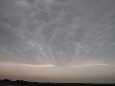
Around 5:30 or 6:00 there were a pair of cells near Woodward, one of which was tornado-warned. After a short time of debate, John and I agreed to drive north on Highway 34 and then east on US 64, toward Alva, Oklahoma. My thought was that we would be ahead of these storms, giving us plenty of time to adjust our position and watch them pass from a safe position. It also gave the storms a little time to mature. This proved to be a good decision. For quite some time the northern storm was dominant. As time wore on, the relatively cool outflow winds from the southern storm were ingested by the northern storm, choking off much of the warm, moist air that it needed to maintain its strength. As the storms evolved, we waited near Ingersoll, Oklahoma, north of Cherokee. There we saw some very impressive mammatus clouds.![]()
As we saw the southern storm become dominant and show signs of rotation we headed south toward Carmen, Oklahoma. Another storm chaser, Greg Nordstrom, an Instructor of Meteorology at Mississippi State University, called us and said he was already doing the same thing for the same reason. We never saw Greg, but evidently he was only a few miles ahead of us. It is always good to know that someone as experienced and knowledgeable as Greg is making the same decision. By the time we approached the Carmen community, the southern storm was rotating and tornado-warned. We drove west through Carmen and pulled over. Here we were able to see a funnel cloud, and then a tornado. We decided to follow it toward Cherokee, to the north. While John drove us north, I called a storm spotter friend, Jennifer New, who relayed our tornado report to the National Weather Service in Norman.
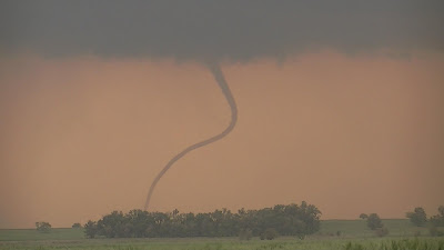
We stopped just south of Cherokee. There we witnessed not one, but two tornadoes on the ground simultaneously.![]()
Since there were no hills or trees to obstruct our view, we were able to watch these “twin” tornadoes for eight minutes. It was an amazing display of nature, and even better, the tornadoes were not impacting people, since this is a very rural area.
![]()
My long-time storm chase partner and friend, John Brown and I left Alabama Friday night and drove to Oklahoma. We actually stopped just past Little Rock and caught an hour or two of sleep in John’s truck. Our plan was to target northern Oklahoma or southern Kansas. Both of those areas were included in a “High Risk” of severe weather by the Storm Prediction Center (SPC). This was only the second time a “High Risk” was issued for an event in the “Day 2” outlook by the SPC. While tornadoes were being reported to our north in Kansas, John and I were hanging back in northwestern Oklahoma. Storms were firing along the dryline in western Oklahoma and moving north-northeast into Kansas. Although we witnessed a wall cloud and a funnel cloud north of Woodward (a town which was later had six fatalities in an overnight tornado), the afternoon storms in our location were not producing tornadoes until they moved into Kansas. This was really testing our patience. But we kept reminding each other of two very important things. One was that the primary window for tornadoes in this area, according to model data, wasn’t until around 7 p.m. and later. The other factor was that often the southern supercell (“tail-end Charlie”) becomes the dominant cell. We were counting on this, because as the afternoon wore on, we were running out of daylight and no more new cells were forming to our southwest.

Around 5:30 or 6:00 there were a pair of cells near Woodward, one of which was tornado-warned. After a short time of debate, John and I agreed to drive north on Highway 34 and then east on US 64, toward Alva, Oklahoma. My thought was that we would be ahead of these storms, giving us plenty of time to adjust our position and watch them pass from a safe position. It also gave the storms a little time to mature. This proved to be a good decision. For quite some time the northern storm was dominant. As time wore on, the relatively cool outflow winds from the southern storm were ingested by the northern storm, choking off much of the warm, moist air that it needed to maintain its strength. As the storms evolved, we waited near Ingersoll, Oklahoma, north of Cherokee. There we saw some very impressive mammatus clouds.
As we saw the southern storm become dominant and show signs of rotation we headed south toward Carmen, Oklahoma. Another storm chaser, Greg Nordstrom, an Instructor of Meteorology at Mississippi State University, called us and said he was already doing the same thing for the same reason. We never saw Greg, but evidently he was only a few miles ahead of us. It is always good to know that someone as experienced and knowledgeable as Greg is making the same decision. By the time we approached the Carmen community, the southern storm was rotating and tornado-warned. We drove west through Carmen and pulled over. Here we were able to see a funnel cloud, and then a tornado. We decided to follow it toward Cherokee, to the north. While John drove us north, I called a storm spotter friend, Jennifer New, who relayed our tornado report to the National Weather Service in Norman.
We stopped just south of Cherokee. There we witnessed not one, but two tornadoes on the ground simultaneously.

Since there were no hills or trees to obstruct our view, we were able to watch these “twin” tornadoes for eight minutes. It was an amazing display of nature, and even better, the tornadoes were not impacting people, since this is a very rural area.
After shooting an 8 minute video of the tornadoes, John and I followed he storms north of Cherokee. By this time, traffic was heavy with storm chasers and it was getting dark. We were tired. We pulled off the road and watched the tornado in the distance as it was being back-lit by lightning. This tornado later affected southeast portions of Wichita, Kansas. It was a successful chase. We were able to witness a few very photogenic tornadoes at sunset that were moving over the open Plains. After midnight, back at the hotel, we watched coverage of the killer tornado in Woodward. It hit especially close to home because John and I spent much of the day in and around the town of Woodward. The National Weather Service in Norman has rated the Woodward tornado an EF3.
...